Indra Haga geodata
Indra Haga (Hordaland) is a populated place; located in Norway in Europe/Oslo (GMT+2) time zone. With population of 900 people, there are 333 cities with bigger population in this country. Compared to other cities in Norway, 55.2% of cities are located further ↑North; 85.9% of cities are located further →East and 77.4% of cities have lower elevation than Indra Haga. Note1


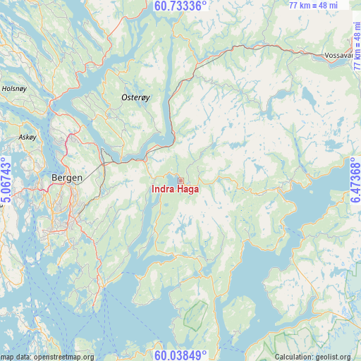
Indra Haga GPS coordinates[2]
60° 23' 16.008" North, 5° 46' 14.016" East
| Map corner | latitude | longitude |
|---|---|---|
| Upper-left | 60.73336°, | 5.06743° |
| Center: | 60.38778°, | 5.77056° |
| Lower-right: | 60.03849°, | 6.47368° |
| Map W x H: | 77.3×77.3 km | = 48×48mi |
| max Lat: | 71.04137° ⇑55.2% North |
| Indra Haga: | 60.38778° |
| min Lat: | ⇓44.8% South 58.0274° |
| min Long | Indra Haga | max Long |
| 4.71485° | 5.77056° | 31.11066° |
| W 14.1%⇐ | ⇒85.9% E |
Elevation
Elevation of Indra Haga is 160 m = 525 ft, and this is 55.8 m = 183 ft above average elevation for this country.
| Max E: |
897 m = 2943 ft | 22.6% |
| Indra Haga | 160 m 525 ft | |
| Avg. | 104.2 m = 342 ft | |
Min E: |
1 m = 3 ft | 77.4% |
See also: Norway elevation on elevation.city.
Geographical zone
Indra Haga is located in North temperate zone (between Tropic of Cancer and the Arctic Circle). Distance of this North polar circle is 686.7 km =426.7 mi to North.| Distance of | km | miles | from Indra Haga |
|---|---|---|---|
| North Pole | 3292.6 | 2045.9 | to North |
| Arctic Circle | 686.7 | 426.7 | to North |
| Tropic Cancer | 4108.6 | 2553 | to South |
| Equator | 6714.5 | 4172.2 | to South |


Nearby cities:
15 places around Indra Haga: (largest is in red/bold)
• Bergen
24.5 km =15.2 mi,  271°
271°
• Dale
22.2 km =13.8 mi,  6°
6°
• Eikelandsosen
16.3 km =10.1 mi,  185°
185°
• Espeland
16.8 km =10.4 mi, 267°
• Hylkje
26.6 km =16.5 mi,  300°
300°
• Indre Arna
16.8 km =10.4 mi,  281°
281°
• Lonevåg
21.5 km =13.4 mi,  315°
315°
• Norheimsund
20.7 km =12.9 mi,  95°
95°
• Osøyro
28.3 km =17.6 mi,  216°
216°
• Stanghelle
18.4 km =11.4 mi,  354°
354°
• Syfteland
24.2 km =15 mi,  226°
226°
• Tysse
1.6 km =1 mi,  201°
201°
• Vaksdal
10 km =6.2 mi, 350°
• Ytre Arna
20.3 km =12.6 mi,  293°
293°
• Øystese
23.2 km =14.4 mi,  89°
89°
Sources, notices
• [Note1] Compared only with cities in Norway existing in our database
• [Src1] Map data: © OpenStreetMap contributors (CC-BY-SA)
• [Src2] Other city data from geonames.org with taken over terms of usage.
• [Src3] Geographical zone / Annual Mean Temperature by Robert A. Rohde @ Wikipedia
