Norheimsund geodata
Norheimsund (Hordaland) is a seat of a second-order administrative division; located in Norway in Europe/Oslo (GMT+2) time zone. With population of 2,146 people, there are 187 cities with bigger population in this country. Compared to other cities in Norway, 56% of cities are located further ↑North; 81% of cities are located further →East and 92.1% of cities have higher elevation than Norheimsund. Note1


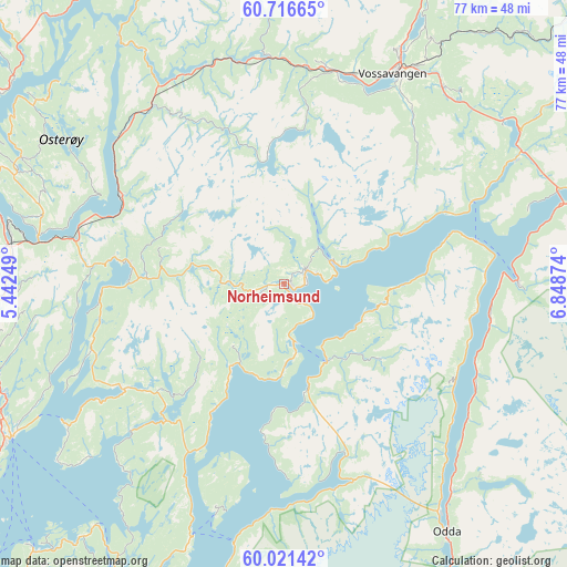
Norheimsund GPS coordinates[2]
60° 22' 15.204" North, 6° 8' 44.232" East
| Map corner | latitude | longitude |
|---|---|---|
| Upper-left | 60.71665°, | 5.44249° |
| Center: | 60.37089°, | 6.14562° |
| Lower-right: | 60.02142°, | 6.84874° |
| Map W x H: | 77.3×77.3 km | = 48×48mi |
| max Lat: | 71.04137° ⇑56% North |
| Norheimsund: | 60.37089° |
| min Lat: | ⇓44% South 58.0274° |
| min Long | Norheimsund | max Long |
| 4.71485° | 6.14562° | 31.11066° |
| W 19%⇐ | ⇒81% E |
Elevation
Elevation of Norheimsund is 3 m = 10 ft, and this is 101.2 m = 332 ft below average elevation for this country.
| Max E: |
897 m = 2943 ft | 92.1% |
| Avg. | 104.2 m = 342 ft | |
| Norheimsund | 3 m = 10 ft | |
Min E: |
1 m = 3 ft | 7.9% |
See also: Norway elevation on elevation.city.
Geographical zone
Norheimsund is located in North temperate zone (between Tropic of Cancer and the Arctic Circle). Distance of this North polar circle is 688.6 km =427.9 mi to North.| Distance of | km | miles | from Norheimsund |
|---|---|---|---|
| North Pole | 3294.4 | 2047 | to North |
| Arctic Circle | 688.6 | 427.9 | to North |
| Tropic Cancer | 4106.7 | 2551.8 | to South |
| Equator | 6712.6 | 4171 | to South |


Nearby cities:
15 places around Norheimsund: (largest is in red/bold)
• Dale
29.9 km =18.6 mi,  323°
323°
• Eikelandsosen
26.4 km =16.4 mi,  236°
236°
• Espeland
37.4 km =23.2 mi,  271°
271°
• Granvin
35.8 km =22.2 mi,  61°
61°
• Indra Haga
20.7 km =12.9 mi,  275°
275°
• Indre Ålvik
17.1 km =10.6 mi,  66°
66°
• Jondal
12.1 km =7.5 mi,  151°
151°
• Kinsarvik
31.5 km =19.6 mi,  89°
89°
• Lofthus
28.7 km =17.8 mi,  98°
98°
• Stanghelle
30.2 km =18.8 mi,  311°
311°
• Tysse
21.2 km =13.2 mi, 270°
• Tyssedal
36.4 km =22.6 mi,  141°
141°
• Vaksdal
25.2 km =15.7 mi,  297°
297°
• Voss
32.2 km =20 mi,  27°
27°
• Øystese
3.2 km =2 mi,  53°
53°
Sources, notices
• [Note1] Compared only with cities in Norway existing in our database
• [Src1] Map data: © OpenStreetMap contributors (CC-BY-SA)
• [Src2] Other city data from geonames.org with taken over terms of usage.
• [Src3] Geographical zone / Annual Mean Temperature by Robert A. Rohde @ Wikipedia
