Osøyro geodata
Osøyro (Hordaland) is a seat of a second-order administrative division; located in Norway in Europe/Oslo (GMT+2) time zone. In our database, there are 488 cities with bigger population. Compared to other cities in Norway, 60.1% of cities are located further ↑North; 90.7% of cities are located further →East and 69% of cities have higher elevation than Osøyro. Note1


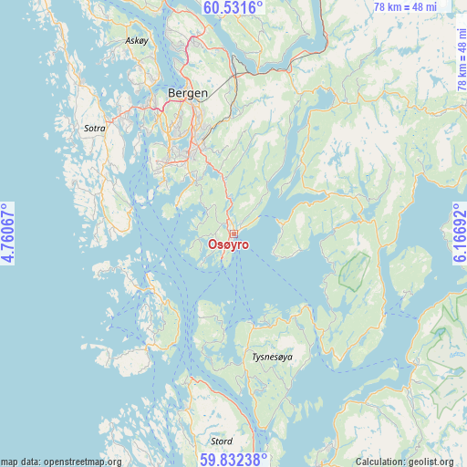
Osøyro GPS coordinates[2]
60° 11' 1.86" North, 5° 27' 49.68" East
| Map corner | latitude | longitude |
|---|---|---|
| Upper-left | 60.5316°, | 4.76067° |
| Center: | 60.18385°, | 5.4638° |
| Lower-right: | 59.83238°, | 6.16692° |
| Map W x H: | 77.7×77.7 km | = 48.3×48.3mi |
| max Lat: | 71.04137° ⇑60.1% North |
| Osøyro: | 60.18385° |
| min Lat: | ⇓39.9% South 58.0274° |
| min Long | Osøyro | max Long |
| 4.71485° | 5.4638° | 31.11066° |
| W 9.3%⇐ | ⇒90.7% E |
Elevation
Elevation of Osøyro is 20 m = 66 ft, and this is 84.2 m = 276 ft below average elevation for this country.
| Max E: |
897 m = 2943 ft | 69% |
| Avg. | 104.2 m = 342 ft | |
| Osøyro | 20 m = 66 ft | |
Min E: |
1 m = 3 ft | 31% |
See also: Norway elevation on elevation.city.
Geographical zone
Osøyro is located in North temperate zone (between Tropic of Cancer and the Arctic Circle). Distance of this North polar circle is 709.4 km =440.8 mi to North.| Distance of | km | miles | from Osøyro |
|---|---|---|---|
| North Pole | 3315.2 | 2060 | to North |
| Arctic Circle | 709.4 | 440.8 | to North |
| Tropic Cancer | 4085.9 | 2538.9 | to South |
| Equator | 6691.8 | 4158.1 | to South |


Nearby cities:
15 places around Osøyro: (largest is in red/bold)
• Bergen
24.5 km =15.2 mi,  341°
341°
• Eikelandsosen
16.8 km =10.4 mi,  67°
67°
• Espeland
22.1 km =13.7 mi,  0°
0°
• Hagavik
3.5 km =2.2 mi,  264°
264°
• Indre Arna
26 km =16.2 mi, 0°
• Klokkarvik
17.9 km =11.1 mi,  284°
284°
• Sandsli
16.5 km =10.3 mi,  323°
323°
• Skogsvågen
21.5 km =13.4 mi,  291°
291°
• Storebø
16.4 km =10.2 mi,  232°
232°
• Syfteland
6.1 km =3.8 mi,  354°
354°
• Søvik
5.5 km =3.4 mi,  310°
310°
• Tysse
26.7 km =16.6 mi,  37°
37°
• Uggdal
20.3 km =12.6 mi,  169°
169°
• Våge
15.9 km =9.9 mi, 168°
• Ytrebygda
16.8 km =10.4 mi, 323°
Sources, notices
• [Note1] Compared only with cities in Norway existing in our database
• [Src1] Map data: © OpenStreetMap contributors (CC-BY-SA)
• [Src2] Other city data from geonames.org with taken over terms of usage.
• [Src3] Geographical zone / Annual Mean Temperature by Robert A. Rohde @ Wikipedia
