Gratangen geodata
Gratangen (Troms) is a seat of a second-order administrative division; located in Norway in Europe/Oslo (GMT+2) time zone. In our database, there are 488 cities with bigger population. Compared to other cities in Norway, 92.1% of cities are located further ↓South; 93.8% of cities are located further ←West and 85% of cities have lower elevation than Gratangen. Note1


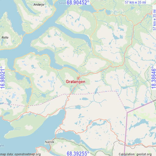
Gratangen GPS coordinates[2]
68° 39' 0" North, 17° 40' 59.988" East
| Map corner | latitude | longitude |
|---|---|---|
| Upper-left | 68.90452°, | 16.98021° |
| Center: | 68.65°, | 17.68333° |
| Lower-right: | 68.39255°, | 18.38646° |
| Map W x H: | 56.9×56.9 km | = 35.4×35.4mi |
| max Lat: | 71.04137° ⇑7.9% North |
| Gratangen: | 68.65° |
| min Lat: | ⇓92.1% South 58.0274° |
| min Long | Gratangen | max Long |
| 4.71485° | 17.68333° | 31.11066° |
| W 93.8%⇐ | ⇒6.2% E |
Elevation
Elevation of Gratangen is 202 m = 663 ft, and this is 97.8 m = 321 ft above average elevation for this country.
| Max E: |
897 m = 2943 ft | 15% |
| Gratangen | 202 m 663 ft | |
| Avg. | 104.2 m = 342 ft | |
Min E: |
1 m = 3 ft | 85% |
See also: Norway elevation on elevation.city.
Geographical zone
Gratangen is located in North Frigid zone (between North Pole and Arctic Circle). Distance of this North polar circle is 232 km =144.2 mi to South.| Distance of | km | miles | from Gratangen |
|---|---|---|---|
| North Pole | 2373.9 | 1475.1 | to North |
| Arctic Circle | 232 | 144.2 | to South |
| Tropic Cancer | 5027.2 | 3123.8 | to South |
| Equator | 7633.2 | 4743 | to South |


Nearby cities:
15 places around Gratangen: (largest is in red/bold)
• Andselv
57 km =35.4 mi,  35°
35°
• Ballangen
48.7 km =30.3 mi,  225°
225°
• Beisfjord
30.7 km =19.1 mi,  186°
186°
• Bjerkvik
12.3 km =7.6 mi,  204°
204°
• Bogen
31.2 km =19.4 mi,  243°
243°
• Brøstadbotn
48.8 km =30.3 mi,  0°
0°
• Evenskjer
45.7 km =28.4 mi,  260°
260°
• Ginnasluokta
31.2 km =19.4 mi,  209°
209°
• Hamnvik
25.2 km =15.7 mi,  304°
304°
• Harstad
48.9 km =30.4 mi,  289°
289°
• Hol
53.6 km =33.3 mi, 257°
• Narvik
25.7 km =16 mi, 203°
• Setermoen
35.6 km =22.1 mi,  48°
48°
• Sjøvegan
25.7 km =16 mi,  14°
14°
• Tennevoll
11.9 km =7.4 mi,  24°
24°
Sources, notices
• [Note1] Compared only with cities in Norway existing in our database
• [Src1] Map data: © OpenStreetMap contributors (CC-BY-SA)
• [Src2] Other city data from geonames.org with taken over terms of usage.
• [Src3] Geographical zone / Annual Mean Temperature by Robert A. Rohde @ Wikipedia
