Setermoen geodata
Setermoen (Troms) is a seat of a second-order administrative division; located in Norway in Europe/Oslo (GMT+2) time zone. With population of 2,410 people, there are 163 cities with bigger population in this country. Compared to other cities in Norway, 93.4% of cities are located further ↓South; 94.9% of cities are located further ←West and 60.1% of cities have lower elevation than Setermoen. Note1


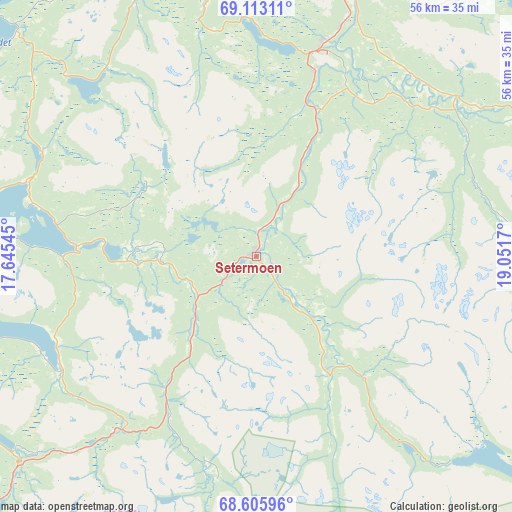
Setermoen GPS coordinates[2]
68° 51' 39.564" North, 18° 20' 54.852" East
| Map corner | latitude | longitude |
|---|---|---|
| Upper-left | 69.11311°, | 17.64545° |
| Center: | 68.86099°, | 18.34857° |
| Lower-right: | 68.60596°, | 19.0517° |
| Map W x H: | 56.4×56.4 km | = 35×35mi |
| max Lat: | 71.04137° ⇑6.6% North |
| Setermoen: | 68.86099° |
| min Lat: | ⇓93.4% South 58.0274° |
| min Long | Setermoen | max Long |
| 4.71485° | 18.34857° | 31.11066° |
| W 94.9%⇐ | ⇒5.1% E |
Elevation
Elevation of Setermoen is 67 m = 220 ft, and this is 37.2 m = 122 ft below average elevation for this country.
| Max E: |
897 m = 2943 ft | 39.9% |
| Avg. | 104.2 m = 342 ft | |
| Setermoen | 67 m = 220 ft | |
Min E: |
1 m = 3 ft | 60.1% |
See also: Norway elevation on elevation.city.
Geographical zone
Setermoen is located in North Frigid zone (between North Pole and Arctic Circle). Distance of this North polar circle is 255.5 km =158.8 mi to South.| Distance of | km | miles | from Setermoen |
|---|---|---|---|
| North Pole | 2350.4 | 1460.5 | to North |
| Arctic Circle | 255.5 | 158.8 | to South |
| Tropic Cancer | 5050.7 | 3138.4 | to South |
| Equator | 7656.6 | 4757.6 | to South |


Nearby cities:
15 places around Setermoen: (largest is in red/bold)
• Andselv
23.7 km =14.7 mi,  16°
16°
• Beisfjord
61.9 km =38.5 mi,  209°
209°
• Bjerkvik
47.2 km =29.3 mi,  222°
222°
• Brøstadbotn
36.3 km =22.6 mi,  314°
314°
• Finnsnes
43.5 km =27 mi,  340°
340°
• Ginnasluokta
65.9 km =40.9 mi, 219°
• Gratangen
35.6 km =22.1 mi,  228°
228°
• Hamnvik
48.1 km =29.9 mi,  259°
259°
• Moen
31.7 km =19.7 mi, 19°
• Narvik
60 km =37.3 mi, 218°
• Sjøvegan
20.2 km =12.6 mi,  273°
273°
• Storsteinnes
55 km =34.2 mi,  39°
39°
• Sørreisa
32.6 km =20.3 mi,  346°
346°
• Tennevoll
25.2 km =15.7 mi,  239°
239°
• Vangsvika
42.2 km =26.2 mi,  324°
324°
Sources, notices
• [Note1] Compared only with cities in Norway existing in our database
• [Src1] Map data: © OpenStreetMap contributors (CC-BY-SA)
• [Src2] Other city data from geonames.org with taken over terms of usage.
• [Src3] Geographical zone / Annual Mean Temperature by Robert A. Rohde @ Wikipedia
