Tennevoll geodata
Tennevoll (Troms) is a seat of a second-order administrative division; located in Norway in Europe/Oslo (GMT+2) time zone. In our database, there are 488 cities with bigger population. Compared to other cities in Norway, 92.7% of cities are located further ↓South; 94.3% of cities are located further ←West and 69% of cities have higher elevation than Tennevoll. Note1


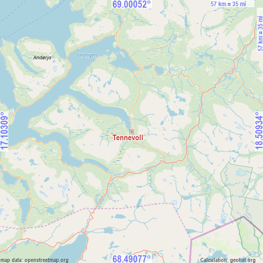
Tennevoll GPS coordinates[2]
68° 44' 49.56" North, 17° 48' 22.356" East
| Map corner | latitude | longitude |
|---|---|---|
| Upper-left | 69.00052°, | 17.10309° |
| Center: | 68.7471°, | 17.80621° |
| Lower-right: | 68.49077°, | 18.50934° |
| Map W x H: | 56.7×56.7 km | = 35.2×35.2mi |
| max Lat: | 71.04137° ⇑7.3% North |
| Tennevoll: | 68.7471° |
| min Lat: | ⇓92.7% South 58.0274° |
| min Long | Tennevoll | max Long |
| 4.71485° | 17.80621° | 31.11066° |
| W 94.3%⇐ | ⇒5.7% E |
Elevation
Elevation of Tennevoll is 20 m = 66 ft, and this is 84.2 m = 276 ft below average elevation for this country.
| Max E: |
897 m = 2943 ft | 69% |
| Avg. | 104.2 m = 342 ft | |
| Tennevoll | 20 m = 66 ft | |
Min E: |
1 m = 3 ft | 31% |
See also: Norway elevation on elevation.city.
Geographical zone
Tennevoll is located in North Frigid zone (between North Pole and Arctic Circle). Distance of this North polar circle is 242.8 km =150.9 mi to South.| Distance of | km | miles | from Tennevoll |
|---|---|---|---|
| North Pole | 2363.1 | 1468.4 | to North |
| Arctic Circle | 242.8 | 150.9 | to South |
| Tropic Cancer | 5038 | 3130.5 | to South |
| Equator | 7644 | 4749.8 | to South |


Nearby cities:
15 places around Tennevoll: (largest is in red/bold)
• Andselv
45.4 km =28.2 mi,  38°
38°
• Beisfjord
42.1 km =26.2 mi,  191°
191°
• Bjerkvik
24.2 km =15 mi,  204°
204°
• Bogen
41.1 km =25.5 mi,  233°
233°
• Brøstadbotn
38.2 km =23.7 mi,  353°
353°
• Evenskjer
53.2 km =33.1 mi,  249°
249°
• Ginnasluokta
43.1 km =26.8 mi,  208°
208°
• Gratangen
11.9 km =7.4 mi, 204°
• Hamnvik
25.8 km =16 mi,  277°
277°
• Harstad
51.2 km =31.8 mi, 276°
• Narvik
37.6 km =23.4 mi, 204°
• Setermoen
25.2 km =15.7 mi,  59°
59°
• Sjøvegan
14.2 km =8.8 mi,  6°
6°
• Sørreisa
46.4 km =28.8 mi,  17°
17°
• Vangsvika
47.2 km =29.3 mi,  356°
356°
Sources, notices
• [Note1] Compared only with cities in Norway existing in our database
• [Src1] Map data: © OpenStreetMap contributors (CC-BY-SA)
• [Src2] Other city data from geonames.org with taken over terms of usage.
• [Src3] Geographical zone / Annual Mean Temperature by Robert A. Rohde @ Wikipedia
