Brøstadbotn geodata
Brøstadbotn (Troms) is a seat of a second-order administrative division; located in Norway in Europe/Oslo (GMT+2) time zone. In our database, there are 488 cities with bigger population. Compared to other cities in Norway, 94.1% of cities are located further ↓South; 94% of cities are located further ←West and 63.8% of cities have higher elevation than Brøstadbotn. Note1


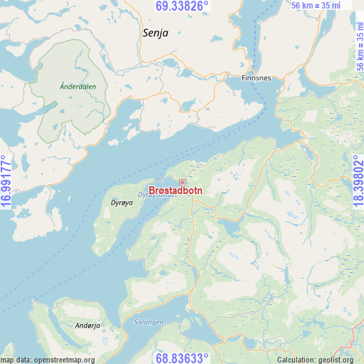
Brøstadbotn GPS coordinates[2]
69° 5' 19.428" North, 17° 41' 41.604" East
| Map corner | latitude | longitude |
|---|---|---|
| Upper-left | 69.33826°, | 16.99177° |
| Center: | 69.08873°, | 17.69489° |
| Lower-right: | 68.83633°, | 18.39802° |
| Map W x H: | 55.8×55.8 km | = 34.7×34.7mi |
| max Lat: | 71.04137° ⇑5.9% North |
| Brøstadbotn: | 69.08873° |
| min Lat: | ⇓94.1% South 58.0274° |
| min Long | Brøstadbotn | max Long |
| 4.71485° | 17.69489° | 31.11066° |
| W 94%⇐ | ⇒6% E |
Elevation
Elevation of Brøstadbotn is 23 m = 75 ft, and this is 81.2 m = 266 ft below average elevation for this country.
| Max E: |
897 m = 2943 ft | 63.8% |
| Avg. | 104.2 m = 342 ft | |
| Brøstadbotn | 23 m = 75 ft | |
Min E: |
1 m = 3 ft | 36.2% |
See also: Norway elevation on elevation.city.
Geographical zone
Brøstadbotn is located in North Frigid zone (between North Pole and Arctic Circle). Distance of this North polar circle is 280.8 km =174.5 mi to South.| Distance of | km | miles | from Brøstadbotn |
|---|---|---|---|
| North Pole | 2325.1 | 1444.7 | to North |
| Arctic Circle | 280.8 | 174.5 | to South |
| Tropic Cancer | 5076 | 3154.1 | to South |
| Equator | 7681.9 | 4773.3 | to South |


Nearby cities:
15 places around Brøstadbotn: (largest is in red/bold)
• Andselv
32.7 km =20.3 mi,  94°
94°
• Bjerkvik
60.2 km =37.4 mi,  185°
185°
• Finnsnes
19.3 km =12 mi,  35°
35°
• Gratangen
48.8 km =30.3 mi,  180°
180°
• Gryllefjord
39.6 km =24.6 mi,  320°
320°
• Hamnvik
40.3 km =25 mi,  211°
211°
• Harstad
56.3 km =35 mi,  234°
234°
• Moen
36.7 km =22.8 mi,  82°
82°
• Setermoen
36.3 km =22.6 mi,  134°
134°
• Sjøvegan
24.7 km =15.3 mi,  165°
165°
• Skaland
42.5 km =26.4 mi,  338°
338°
• Storsteinnes
63.2 km =39.3 mi,  74°
74°
• Sørreisa
19.2 km =11.9 mi, 70°
• Tennevoll
38.2 km =23.7 mi, 173°
• Vangsvika
9.2 km =5.7 mi,  9°
9°
Sources, notices
• [Note1] Compared only with cities in Norway existing in our database
• [Src1] Map data: © OpenStreetMap contributors (CC-BY-SA)
• [Src2] Other city data from geonames.org with taken over terms of usage.
• [Src3] Geographical zone / Annual Mean Temperature by Robert A. Rohde @ Wikipedia
