Etne geodata
Etne (Hordaland) is a seat of a second-order administrative division; located in Norway in Europe/Oslo (GMT+2) time zone. With population of 1,002 people, there are 312 cities with bigger population in this country. Compared to other cities in Norway, 73.9% of cities are located further ↑North; 83.5% of cities are located further →East and 84.8% of cities have higher elevation than Etne. Note1


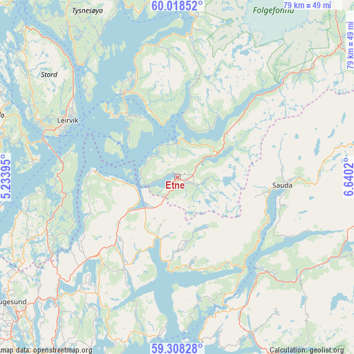
Etne GPS coordinates[2]
59° 39' 55.008" North, 5° 56' 13.488" East
| Map corner | latitude | longitude |
|---|---|---|
| Upper-left | 60.01852°, | 5.23395° |
| Center: | 59.66528°, | 5.93708° |
| Lower-right: | 59.30828°, | 6.6402° |
| Map W x H: | 79×79 km | = 49.1×49.1mi |
| max Lat: | 71.04137° ⇑73.9% North |
| Etne: | 59.66528° |
| min Lat: | ⇓26.1% South 58.0274° |
| min Long | Etne | max Long |
| 4.71485° | 5.93708° | 31.11066° |
| W 16.5%⇐ | ⇒83.5% E |
Elevation
Elevation of Etne is 8 m = 26 ft, and this is 96.2 m = 316 ft below average elevation for this country.
| Max E: |
897 m = 2943 ft | 84.8% |
| Avg. | 104.2 m = 342 ft | |
| Etne | 8 m = 26 ft | |
Min E: |
1 m = 3 ft | 15.2% |
See also: Norway elevation on elevation.city.
Geographical zone
Etne is located in North temperate zone (between Tropic of Cancer and the Arctic Circle). Distance of this North polar circle is 767 km =476.6 mi to North.| Distance of | km | miles | from Etne |
|---|---|---|---|
| North Pole | 3372.9 | 2095.8 | to North |
| Arctic Circle | 767 | 476.6 | to North |
| Tropic Cancer | 4028.2 | 2503 | to South |
| Equator | 6634.2 | 4122.3 | to South |


Nearby cities:
15 places around Etne: (largest is in red/bold)
• Aksdal
38.6 km =24 mi,  225°
225°
• Leirvik
27.6 km =17.1 mi,  297°
297°
• Mosterhamn
31.2 km =19.4 mi,  276°
276°
• Rosendal
35.9 km =22.3 mi,  6°
6°
• Sagvåg
33.3 km =20.7 mi,  292°
292°
• Sand
26.8 km =16.7 mi,  138°
138°
• Sandeid
14.1 km =8.8 mi,  197°
197°
• Sauda
23.5 km =14.6 mi,  93°
93°
• Skjold
26.7 km =16.6 mi, 227°
• Skånevik
7.5 km =4.7 mi,  0°
0°
• Sveio
35.7 km =22.2 mi,  247°
247°
• Sæbøvik
19.2 km =11.9 mi,  318°
318°
• Uskedalen
30.1 km =18.7 mi,  352°
352°
• Valvatna
31.3 km =19.4 mi, 291°
• Ølen
9.9 km =6.2 mi, 226°
Sources, notices
• [Note1] Compared only with cities in Norway existing in our database
• [Src1] Map data: © OpenStreetMap contributors (CC-BY-SA)
• [Src2] Other city data from geonames.org with taken over terms of usage.
• [Src3] Geographical zone / Annual Mean Temperature by Robert A. Rohde @ Wikipedia
