Sauda geodata
Sauda (Rogaland) is a seat of a second-order administrative division; located in Norway in Europe/Oslo (GMT+2) time zone. With population of 4,290 people, there are 103 cities with bigger population in this country. Compared to other cities in Norway, 74.7% of cities are located further ↑North; 79.4% of cities are located further →East and 79% of cities have higher elevation than Sauda. Note1


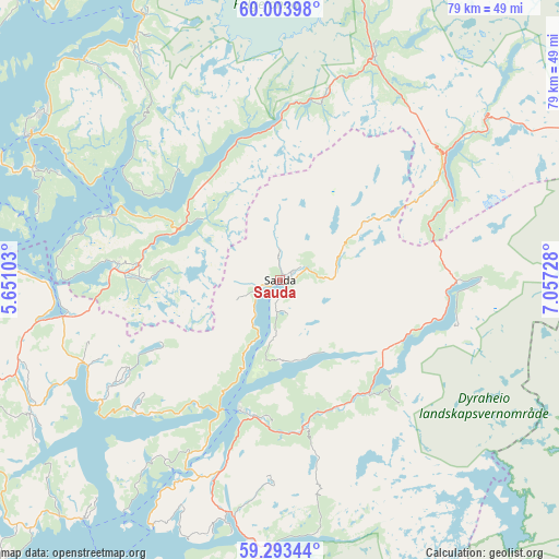
Sauda GPS coordinates[2]
59° 39' 2.124" North, 6° 21' 14.94" East
| Map corner | latitude | longitude |
|---|---|---|
| Upper-left | 60.00398°, | 5.65103° |
| Center: | 59.65059°, | 6.35415° |
| Lower-right: | 59.29344°, | 7.05728° |
| Map W x H: | 79×79 km | = 49.1×49.1mi |
| max Lat: | 71.04137° ⇑74.7% North |
| Sauda: | 59.65059° |
| min Lat: | ⇓25.3% South 58.0274° |
| min Long | Sauda | max Long |
| 4.71485° | 6.35415° | 31.11066° |
| W 20.6%⇐ | ⇒79.4% E |
Elevation
Elevation of Sauda is 11 m = 36 ft, and this is 93.2 m = 306 ft below average elevation for this country.
| Max E: |
897 m = 2943 ft | 79% |
| Avg. | 104.2 m = 342 ft | |
| Sauda | 11 m = 36 ft | |
Min E: |
1 m = 3 ft | 21% |
See also: Norway elevation on elevation.city.
Geographical zone
Sauda is located in North temperate zone (between Tropic of Cancer and the Arctic Circle). Distance of this North polar circle is 768.7 km =477.6 mi to North.| Distance of | km | miles | from Sauda |
|---|---|---|---|
| North Pole | 3374.5 | 2096.8 | to North |
| Arctic Circle | 768.7 | 477.6 | to North |
| Tropic Cancer | 4026.6 | 2502 | to South |
| Equator | 6632.5 | 4121.2 | to South |


Nearby cities:
15 places around Sauda: (largest is in red/bold)
• Etne
23.5 km =14.6 mi,  273°
273°
• Hjelmelandsvågen
47 km =29.2 mi,  192°
192°
• Leirvik
50 km =31.1 mi,  286°
286°
• Mosterhamn
54.6 km =33.9 mi,  275°
275°
• Odda
47.7 km =29.6 mi,  12°
12°
• Rosendal
41.9 km =26 mi,  332°
332°
• Sand
19.3 km =12 mi,  197°
197°
• Sandeid
30.1 km =18.7 mi,  246°
246°
• Skjold
46.2 km =28.7 mi, 249°
• Skånevik
25.1 km =15.6 mi, 291°
• Sæbøvik
39.5 km =24.5 mi, 293°
• Tyssedal
53 km =32.9 mi, 12°
• Uskedalen
41.7 km =25.9 mi,  318°
318°
• Valvatna
54.1 km =33.6 mi, 283°
• Ølen
31.1 km =19.3 mi,  260°
260°
Sources, notices
• [Note1] Compared only with cities in Norway existing in our database
• [Src1] Map data: © OpenStreetMap contributors (CC-BY-SA)
• [Src2] Other city data from geonames.org with taken over terms of usage.
• [Src3] Geographical zone / Annual Mean Temperature by Robert A. Rohde @ Wikipedia
