Rosendal geodata
Rosendal (Hordaland) is a seat of a second-order administrative division; located in Norway in Europe/Oslo (GMT+2) time zone. With population of 945 people, there are 326 cities with bigger population in this country. Compared to other cities in Norway, 65% of cities are located further ↑North; 82.9% of cities are located further →East and 81.6% of cities have higher elevation than Rosendal. Note1


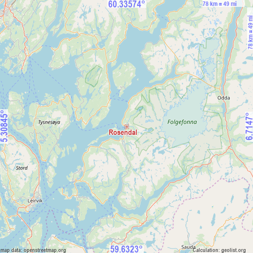
Rosendal GPS coordinates[2]
59° 59' 9.204" North, 6° 0' 41.652" East
| Map corner | latitude | longitude |
|---|---|---|
| Upper-left | 60.33574°, | 5.30845° |
| Center: | 59.98589°, | 6.01157° |
| Lower-right: | 59.6323°, | 6.7147° |
| Map W x H: | 78.2×78.2 km | = 48.6×48.6mi |
| max Lat: | 71.04137° ⇑65% North |
| Rosendal: | 59.98589° |
| min Lat: | ⇓35% South 58.0274° |
| min Long | Rosendal | max Long |
| 4.71485° | 6.01157° | 31.11066° |
| W 17.1%⇐ | ⇒82.9% E |
Elevation
Elevation of Rosendal is 10 m = 33 ft, and this is 94.2 m = 309 ft below average elevation for this country.
| Max E: |
897 m = 2943 ft | 81.6% |
| Avg. | 104.2 m = 342 ft | |
| Rosendal | 10 m = 33 ft | |
Min E: |
1 m = 3 ft | 18.4% |
See also: Norway elevation on elevation.city.
Geographical zone
Rosendal is located in North temperate zone (between Tropic of Cancer and the Arctic Circle). Distance of this North polar circle is 731.4 km =454.5 mi to North.| Distance of | km | miles | from Rosendal |
|---|---|---|---|
| North Pole | 3337.3 | 2073.7 | to North |
| Arctic Circle | 731.4 | 454.5 | to North |
| Tropic Cancer | 4063.9 | 2525.2 | to South |
| Equator | 6669.8 | 4144.4 | to South |


Nearby cities:
15 places around Rosendal: (largest is in red/bold)
• Eikelandsosen
32.1 km =19.9 mi,  332°
332°
• Etne
35.9 km =22.3 mi,  186°
186°
• Fitjar
39.4 km =24.5 mi,  258°
258°
• Hagavik
40.2 km =25 mi,  302°
302°
• Jondal
34.9 km =21.7 mi,  22°
22°
• Leirvik
36.6 km =22.7 mi,  231°
231°
• Odda
31.1 km =19.3 mi,  72°
72°
• Osøyro
37.5 km =23.3 mi,  305°
305°
• Skånevik
28.4 km =17.6 mi, 188°
• Sæbøvik
27.2 km =16.9 mi,  218°
218°
• Tyssedal
33.7 km =20.9 mi,  64°
64°
• Uggdal
26.9 km =16.7 mi,  274°
274°
• Uskedalen
10.1 km =6.3 mi, 234°
• Valvatna
41.2 km =25.6 mi, 233°
• Våge
27.9 km =17.3 mi,  283°
283°
Sources, notices
• [Note1] Compared only with cities in Norway existing in our database
• [Src1] Map data: © OpenStreetMap contributors (CC-BY-SA)
• [Src2] Other city data from geonames.org with taken over terms of usage.
• [Src3] Geographical zone / Annual Mean Temperature by Robert A. Rohde @ Wikipedia
