Storebø geodata
Storebø (Hordaland) is a seat of a second-order administrative division; located in Norway in Europe/Oslo (GMT+2) time zone. With population of 1,026 people, there are 308 cities with bigger population in this country. Compared to other cities in Norway, 61.7% of cities are located further ↑North; 96% of cities are located further →East and 55.9% of cities have higher elevation than Storebø. Note1


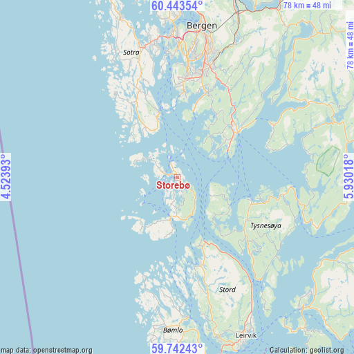
Storebø GPS coordinates[2]
60° 5' 41.46" North, 5° 13' 37.38" East
| Map corner | latitude | longitude |
|---|---|---|
| Upper-left | 60.44354°, | 4.52393° |
| Center: | 60.09485°, | 5.22705° |
| Lower-right: | 59.74243°, | 5.93018° |
| Map W x H: | 78×78 km | = 48.5×48.5mi |
| max Lat: | 71.04137° ⇑61.7% North |
| Storebø: | 60.09485° |
| min Lat: | ⇓38.3% South 58.0274° |
| min Long | Storebø | max Long |
| 4.71485° | 5.22705° | 31.11066° |
| W 4%⇐ | ⇒96% E |
Elevation
Elevation of Storebø is 33 m = 108 ft, and this is 71.2 m = 234 ft below average elevation for this country.
| Max E: |
897 m = 2943 ft | 55.9% |
| Avg. | 104.2 m = 342 ft | |
| Storebø | 33 m = 108 ft | |
Min E: |
1 m = 3 ft | 44.1% |
See also: Norway elevation on elevation.city.
Geographical zone
Storebø is located in North temperate zone (between Tropic of Cancer and the Arctic Circle). Distance of this North polar circle is 719.3 km =447 mi to North.| Distance of | km | miles | from Storebø |
|---|---|---|---|
| North Pole | 3325.1 | 2066.1 | to North |
| Arctic Circle | 719.3 | 447 | to North |
| Tropic Cancer | 4076 | 2532.7 | to South |
| Equator | 6681.9 | 4151.9 | to South |


Nearby cities:
15 places around Storebø: (largest is in red/bold)
• Eikelandsosen
32.9 km =20.4 mi,  60°
60°
• Fitjar
20.3 km =12.6 mi,  165°
165°
• Hagavik
13.6 km =8.5 mi,  45°
45°
• Klokkarvik
15 km =9.3 mi,  343°
343°
• Knappskog
33 km =20.5 mi, 343°
• Osøyro
16.4 km =10.2 mi, 52°
• Rubbestadneset
31.1 km =19.3 mi,  175°
175°
• Sandsli
23.4 km =14.5 mi,  7°
7°
• Skogsvågen
19.1 km =11.9 mi, 338°
• Straume
30.2 km =18.8 mi,  348°
348°
• Syfteland
20.2 km =12.6 mi,  38°
38°
• Søvik
16.1 km =10 mi,  33°
33°
• Uggdal
19.6 km =12.2 mi,  121°
121°
• Våge
17.4 km =10.8 mi,  109°
109°
• Ytrebygda
23.6 km =14.7 mi, 7°
Sources, notices
• [Note1] Compared only with cities in Norway existing in our database
• [Src1] Map data: © OpenStreetMap contributors (CC-BY-SA)
• [Src2] Other city data from geonames.org with taken over terms of usage.
• [Src3] Geographical zone / Annual Mean Temperature by Robert A. Rohde @ Wikipedia
