Sistranda geodata
Sistranda (Trøndelag) is a seat of a second-order administrative division; located in Norway in Europe/Oslo (GMT+2) time zone. With population of 685 people, there are 387 cities with bigger population in this country. Compared to other cities in Norway, 78.6% of cities are located further ↓South; 61.2% of cities are located further →East and 100% of cities have higher elevation than Sistranda. Note1


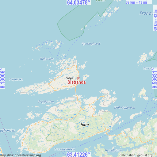
Sistranda GPS coordinates[2]
63° 43' 30.828" North, 8° 49' 59.448" East
| Map corner | latitude | longitude |
|---|---|---|
| Upper-left | 64.03478°, | 8.13006° |
| Center: | 63.72523°, | 8.83318° |
| Lower-right: | 63.41226°, | 9.53631° |
| Map W x H: | 69.2×69.2 km | = 43×43mi |
| max Lat: | 71.04137° ⇑21.4% North |
| Sistranda: | 63.72523° |
| min Lat: | ⇓78.6% South 58.0274° |
| min Long | Sistranda | max Long |
| 4.71485° | 8.83318° | 31.11066° |
| W 38.8%⇐ | ⇒61.2% E |
Elevation
Elevation of Sistranda is 1 m = 3 ft, and this is 103.2 m = 339 ft below average elevation for this country.
| Max E: |
897 m = 2943 ft | 100% |
| Avg. | 104.2 m = 342 ft | |
| Sistranda | 1 m = 3 ft | |
Min E: |
1 m = 3 ft | 0% |
See also: Norway elevation on elevation.city.
Geographical zone
Sistranda is located in North temperate zone (between Tropic of Cancer and the Arctic Circle). Distance of this North polar circle is 315.6 km =196.1 mi to North.| Distance of | km | miles | from Sistranda |
|---|---|---|---|
| North Pole | 2921.5 | 1815.3 | to North |
| Arctic Circle | 315.6 | 196.1 | to North |
| Tropic Cancer | 4479.7 | 2783.6 | to South |
| Equator | 7085.6 | 4402.8 | to South |


Nearby cities:
15 places around Sistranda: (largest is in red/bold)
• Aure
53 km =32.9 mi,  196°
196°
• Botngård
48.2 km =30 mi,  84°
84°
• Brekstad
41.2 km =25.6 mi,  95°
95°
• Børsa
75.6 km =47 mi,  125°
125°
• Fillan
14.8 km =9.2 mi,  153°
153°
• Hopen
49.7 km =30.9 mi,  234°
234°
• Krokstadøra
48.9 km =30.4 mi,  137°
137°
• Kyrksæterøra
50 km =31.1 mi,  165°
165°
• Lensvik
53.5 km =33.2 mi,  116°
116°
• Liabøen
71.8 km =44.6 mi, 201°
• Orkanger
68.6 km =42.6 mi, 132°
• Rindal
76.8 km =47.7 mi, 165°
• Rissa
57.8 km =35.9 mi,  105°
105°
• Å i Åfjord
73.1 km =45.4 mi,  69°
69°
• Årnes
73.1 km =45.4 mi, 68°
Sources, notices
• [Note1] Compared only with cities in Norway existing in our database
• [Src1] Map data: © OpenStreetMap contributors (CC-BY-SA)
• [Src2] Other city data from geonames.org with taken over terms of usage.
• [Src3] Geographical zone / Annual Mean Temperature by Robert A. Rohde @ Wikipedia
