Hokksund geodata
Hokksund (Buskerud) is a seat of a second-order administrative division; located in Norway in Europe/Oslo (GMT+2) time zone. In our database, there are 488 cities with bigger population. Compared to other cities in Norway, 71.2% of cities are located further ↑North; 52.5% of cities are located further →East and 75.8% of cities have higher elevation than Hokksund. Note1


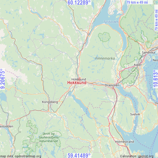
Hokksund GPS coordinates[2]
59° 46' 14.772" North, 9° 54' 35.532" East
| Map corner | latitude | longitude |
|---|---|---|
| Upper-left | 60.12289°, | 9.20675° |
| Center: | 59.77077°, | 9.90987° |
| Lower-right: | 59.41489°, | 10.613° |
| Map W x H: | 78.7×78.7 km | = 48.9×48.9mi |
| max Lat: | 71.04137° ⇑71.2% North |
| Hokksund: | 59.77077° |
| min Lat: | ⇓28.8% South 58.0274° |
| min Long | Hokksund | max Long |
| 4.71485° | 9.90987° | 31.11066° |
| W 47.5%⇐ | ⇒52.5% E |
Elevation
Elevation of Hokksund is 13 m = 43 ft, and this is 91.2 m = 299 ft below average elevation for this country.
| Max E: |
897 m = 2943 ft | 75.8% |
| Avg. | 104.2 m = 342 ft | |
| Hokksund | 13 m = 43 ft | |
Min E: |
1 m = 3 ft | 24.2% |
See also: Norway elevation on elevation.city.
Geographical zone
Hokksund is located in North temperate zone (between Tropic of Cancer and the Arctic Circle). Distance of this North polar circle is 755.3 km =469.3 mi to North.| Distance of | km | miles | from Hokksund |
|---|---|---|---|
| North Pole | 3361.2 | 2088.6 | to North |
| Arctic Circle | 755.3 | 469.3 | to North |
| Tropic Cancer | 4040 | 2510.3 | to South |
| Equator | 6645.9 | 4129.6 | to South |


Nearby cities:
15 places around Hokksund: (largest is in red/bold)
• Asker
30.3 km =18.8 mi,  76°
76°
• Blakstad
31.5 km =19.6 mi, 80°
• Drammen
16.8 km =10.4 mi,  100°
100°
• Hvittingfoss
32.2 km =20 mi,  169°
169°
• Kongsberg
18.5 km =11.5 mi,  232°
232°
• Lampeland
19.8 km =12.3 mi,  291°
291°
• Lierbyen
18.8 km =11.7 mi, 84°
• Mjøndalen
6.8 km =4.2 mi,  109°
109°
• Røyken
26.9 km =16.7 mi, 95°
• Sande
26.4 km =16.4 mi,  140°
140°
• Selvik
30 km =18.6 mi, 139°
• Skoger
20.3 km =12.6 mi, 108°
• Sylling
25.3 km =15.7 mi,  57°
57°
• Tranby
20.1 km =12.5 mi, 77°
• Vikersund
22.4 km =13.9 mi,  11°
11°
Sources, notices
• [Note1] Compared only with cities in Norway existing in our database
• [Src1] Map data: © OpenStreetMap contributors (CC-BY-SA)
• [Src2] Other city data from geonames.org with taken over terms of usage.
• [Src3] Geographical zone / Annual Mean Temperature by Robert A. Rohde @ Wikipedia
