Åndalsnes geodata
Åndalsnes (Møre og Romsdal) is a seat of a second-order administrative division; located in Norway in Europe/Oslo (GMT+2) time zone. With population of 2,035 people, there are 198 cities with bigger population in this country. Compared to other cities in Norway, 69% of cities are located further ↓South; 69.3% of cities are located further →East and 69.8% of cities have higher elevation than Åndalsnes. Note1


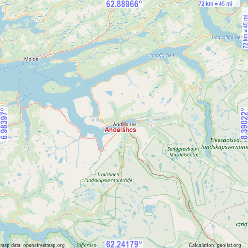
Åndalsnes GPS coordinates[2]
62° 34' 2.964" North, 7° 41' 13.524" East
| Map corner | latitude | longitude |
|---|---|---|
| Upper-left | 62.88966°, | 6.98397° |
| Center: | 62.56749°, | 7.68709° |
| Lower-right: | 62.24179°, | 8.39022° |
| Map W x H: | 72×72 km | = 44.7×44.7mi |
| max Lat: | 71.04137° ⇑31% North |
| Åndalsnes: | 62.56749° |
| min Lat: | ⇓69% South 58.0274° |
| min Long | Åndalsnes | max Long |
| 4.71485° | 7.68709° | 31.11066° |
| W 30.7%⇐ | ⇒69.3% E |
Elevation
Elevation of Åndalsnes is 19 m = 62 ft, and this is 85.2 m = 280 ft below average elevation for this country.
| Max E: |
897 m = 2943 ft | 69.8% |
| Avg. | 104.2 m = 342 ft | |
| Åndalsnes | 19 m = 62 ft | |
Min E: |
1 m = 3 ft | 30.2% |
See also: Norway elevation on elevation.city.
Geographical zone
Åndalsnes is located in North temperate zone (between Tropic of Cancer and the Arctic Circle). Distance of this North polar circle is 444.3 km =276.1 mi to North.| Distance of | km | miles | from Åndalsnes |
|---|---|---|---|
| North Pole | 3050.2 | 1895.3 | to North |
| Arctic Circle | 444.3 | 276.1 | to North |
| Tropic Cancer | 4350.9 | 2703.5 | to South |
| Equator | 6956.9 | 4322.8 | to South |


Nearby cities:
15 places around Åndalsnes: (largest is in red/bold)
• Aukra
46.8 km =29.1 mi,  300°
300°
• Batnfjordsøra
36.4 km =22.6 mi,  358°
358°
• Eide
40.8 km =25.4 mi,  342°
342°
• Eidsvåg
30.2 km =18.8 mi,  39°
39°
• Elnesvågen
42.4 km =26.3 mi,  318°
318°
• Giskemo
43.1 km =26.8 mi,  257°
257°
• Hjelset
25.7 km =16 mi, 337°
• Molde
32.9 km =20.4 mi,  305°
305°
• Sjøholt
45.8 km =28.5 mi, 258°
• Stordal
41.5 km =25.8 mi,  240°
240°
• Sunndalsøra
46.4 km =28.8 mi,  75°
75°
• Tingvoll
46.6 km =29 mi,  34°
34°
• Tomra
38.7 km =24 mi,  272°
272°
• Valldal
37.1 km =23.1 mi,  215°
215°
• Vestnes
31.4 km =19.5 mi,  281°
281°
Sources, notices
• [Note1] Compared only with cities in Norway existing in our database
• [Src1] Map data: © OpenStreetMap contributors (CC-BY-SA)
• [Src2] Other city data from geonames.org with taken over terms of usage.
• [Src3] Geographical zone / Annual Mean Temperature by Robert A. Rohde @ Wikipedia
