Bruhagen geodata
Bruhagen (Møre og Romsdal) is a seat of a second-order administrative division; located in Norway in Europe/Oslo (GMT+2) time zone. In our database, there are 488 cities with bigger population. Compared to other cities in Norway, 73.3% of cities are located further ↓South; 69.6% of cities are located further →East and 69% of cities have higher elevation than Bruhagen. Note1


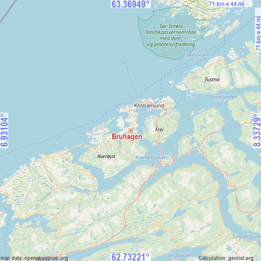
Bruhagen GPS coordinates[2]
63° 3' 9.324" North, 7° 38' 2.976" East
| Map corner | latitude | longitude |
|---|---|---|
| Upper-left | 63.36949°, | 6.93104° |
| Center: | 63.05259°, | 7.63416° |
| Lower-right: | 62.73221°, | 8.33729° |
| Map W x H: | 70.9×70.9 km | = 44.1×44.1mi |
| max Lat: | 71.04137° ⇑26.7% North |
| Bruhagen: | 63.05259° |
| min Lat: | ⇓73.3% South 58.0274° |
| min Long | Bruhagen | max Long |
| 4.71485° | 7.63416° | 31.11066° |
| W 30.4%⇐ | ⇒69.6% E |
Elevation
Elevation of Bruhagen is 20 m = 66 ft, and this is 84.2 m = 276 ft below average elevation for this country.
| Max E: |
897 m = 2943 ft | 69% |
| Avg. | 104.2 m = 342 ft | |
| Bruhagen | 20 m = 66 ft | |
Min E: |
1 m = 3 ft | 31% |
See also: Norway elevation on elevation.city.
Geographical zone
Bruhagen is located in North temperate zone (between Tropic of Cancer and the Arctic Circle). Distance of this North polar circle is 390.4 km =242.6 mi to North.| Distance of | km | miles | from Bruhagen |
|---|---|---|---|
| North Pole | 2996.3 | 1861.8 | to North |
| Arctic Circle | 390.4 | 242.6 | to North |
| Tropic Cancer | 4404.9 | 2737.1 | to South |
| Equator | 7010.8 | 4356.3 | to South |


Nearby cities:
15 places around Bruhagen: (largest is in red/bold)
• Aukra
47.7 km =29.6 mi,  231°
231°
• Aure
50.9 km =31.6 mi,  61°
61°
• Batnfjordsøra
17.7 km =11 mi,  173°
173°
• Bud
39.8 km =24.7 mi,  246°
246°
• Eide
17.8 km =11.1 mi,  212°
212°
• Eidsvåg
37.7 km =23.4 mi,  144°
144°
• Elnesvågen
33.4 km =20.8 mi, 228°
• Falkhytta
46.8 km =29.1 mi, 233°
• Hjelset
31.1 km =19.3 mi,  193°
193°
• Hopen
49.7 km =30.9 mi,  22°
22°
• Kristiansund
8 km =5 mi,  36°
36°
• Liabøen
35.2 km =21.9 mi,  77°
77°
• Molde
42.5 km =26.4 mi, 214°
• Rensvik
10.7 km =6.6 mi, 61°
• Tingvoll
32.7 km =20.3 mi,  118°
118°
Sources, notices
• [Note1] Compared only with cities in Norway existing in our database
• [Src1] Map data: © OpenStreetMap contributors (CC-BY-SA)
• [Src2] Other city data from geonames.org with taken over terms of usage.
• [Src3] Geographical zone / Annual Mean Temperature by Robert A. Rohde @ Wikipedia
