Tokoroa geodata
Tokoroa (Waikato) is a populated place; located in New Zealand in Pacific/Auckland (GMT+12) time zone. With population of 14,277 people, there are 35 cities with bigger population in this country. Compared to other cities in New Zealand, 61.4% of cities are located further ↓South; 84.5% of cities are located further ←West and 95.7% of cities have lower elevation than Tokoroa. Note1


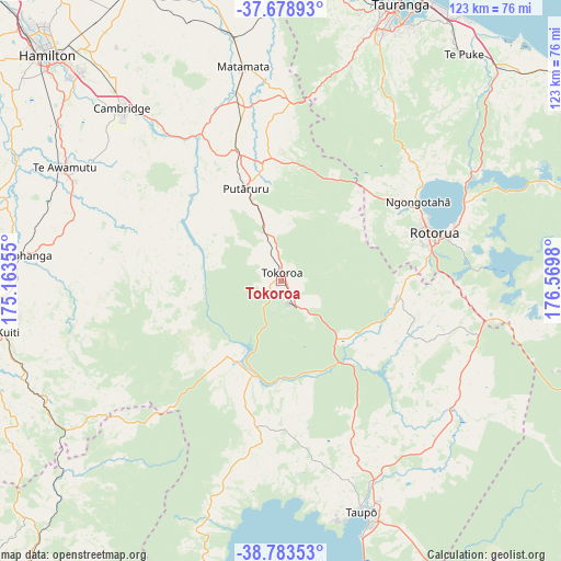
Tokoroa GPS coordinates[2]
38° 13' 59.988" South, 175° 52' 0.012" East
| Map corner | latitude | longitude |
|---|---|---|
| Upper-left | -37.67893°, | 175.16355° |
| Center: | -38.23333°, | 175.86667° |
| Lower-right: | -38.78353°, | 176.5698° |
| Map W x H: | 122.8×122.8 km | = 76.3×76.3mi |
| max Lat: | -34.99604° ⇑38.6% North |
| Tokoroa: | -38.23333° |
| min Lat: | ⇓61.4% South -46.6° |
| min Long | Tokoroa | max Long |
| -176.55973° | 175.86667° | 178.33333° |
| W 84.5%⇐ | ⇒15.5% E |
Elevation
Elevation of Tokoroa is 346 m = 1135 ft, and this is 261.6 m = 858 ft above average elevation for this country.
| Max E: |
819 m = 2687 ft | 4.3% |
| Tokoroa | 346 m 1135 ft | |
| Avg. | 84.4 m = 277 ft | |
Min E: |
3 m = 10 ft | 95.7% |
See also: New Zealand elevation on elevation.city.
Geographical zone
Tokoroa is located in South temperate zone (between Tropic of Capricorn and the Antarctic Circle). Distance of this Southern Tropic circle is 1645.2 km =1022.3 mi to North.| Distance of | km | miles | from Tokoroa |
|---|---|---|---|
| Equator | 4251.1 | 2641.5 | to North |
| Tropic Capricorn | 1645.2 | 1022.3 | to North |
| Antarctic Circle | 3150 | 1957.3 | to South |
| South Pole | 5755.9 | 3576.5 | to South |


Nearby cities:
15 places around Tokoroa: (largest is in red/bold)
• Cambridge
54.3 km =33.7 mi,  316°
316°
• Hamilton
71.5 km =44.4 mi,  314°
314°
• Katikati
76.1 km =47.3 mi,  3°
3°
• Kawerau
74.3 km =46.2 mi,  78°
78°
• Maketu
72.8 km =45.2 mi,  44°
44°
• Mamaku
24.1 km =15 mi,  51°
51°
• Matamata
47.9 km =29.8 mi,  349°
349°
• Otorohanga
58.5 km =36.4 mi,  275°
275°
• Paengaroa
66.8 km =41.5 mi, 46°
• Reporoa
47.1 km =29.3 mi,  118°
118°
• Rotorua
34.7 km =21.6 mi,  72°
72°
• Taupo
53.5 km =33.2 mi,  159°
159°
• Tauranga
66.3 km =41.2 mi,  23°
23°
• Tirau
29.6 km =18.4 mi,  339°
339°
• Waharoa
52.6 km =32.7 mi, 350°
Sources, notices
• [Note1] Compared only with cities in New Zealand existing in our database
• [Src1] Map data: © OpenStreetMap contributors (CC-BY-SA)
• [Src2] Other city data from geonames.org with taken over terms of usage.
• [Src3] Geographical zone / Annual Mean Temperature by Robert A. Rohde @ Wikipedia
