Rotorua geodata
Rotorua (Bay of Plenty) is a seat of a second-order administrative division; located in New Zealand in Pacific/Auckland (GMT+12) time zone. With population of 65,901 people, there are 11 cities with bigger population in this country. Compared to other cities in New Zealand, 62.8% of cities are located further ↓South; 89.4% of cities are located further ←West and 92.8% of cities have lower elevation than Rotorua. Note1


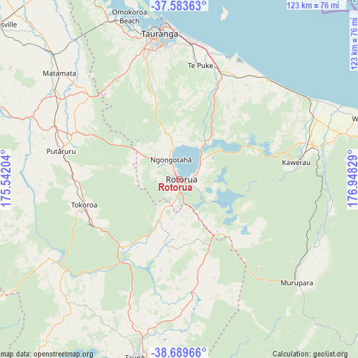
Rotorua GPS coordinates[2]
38° 8' 19.464" South, 176° 14' 42.576" East
| Map corner | latitude | longitude |
|---|---|---|
| Upper-left | -37.58363°, | 175.54204° |
| Center: | -38.13874°, | 176.24516° |
| Lower-right: | -38.68966°, | 176.94829° |
| Map W x H: | 123×123 km | = 76.4×76.4mi |
| max Lat: | -34.99604° ⇑37.2% North |
| Rotorua: | -38.13874° |
| min Lat: | ⇓62.8% South -46.6° |
| min Long | Rotorua | max Long |
| -176.55973° | 176.24516° | 178.33333° |
| W 89.4%⇐ | ⇒10.6% E |
Elevation
Elevation of Rotorua is 287 m = 942 ft, and this is 202.6 m = 665 ft above average elevation for this country.
| Max E: |
819 m = 2687 ft | 7.2% |
| Rotorua | 287 m 942 ft | |
| Avg. | 84.4 m = 277 ft | |
Min E: |
3 m = 10 ft | 92.8% |
See also: Rotorua elevation on elevation.city.
Geographical zone
Rotorua is located in South temperate zone (between Tropic of Capricorn and the Antarctic Circle). Distance of this Southern Tropic circle is 1634.7 km =1015.8 mi to North.| Distance of | km | miles | from Rotorua |
|---|---|---|---|
| Equator | 4240.6 | 2635 | to North |
| Tropic Capricorn | 1634.7 | 1015.8 | to North |
| Antarctic Circle | 3160.5 | 1963.8 | to South |
| South Pole | 5766.4 | 3583.1 | to South |


Nearby cities:
15 places around Rotorua: (largest is in red/bold)
• Edgecumbe
54.3 km =33.7 mi,  71°
71°
• Kawerau
40 km =24.9 mi,  83°
83°
• Maketu
45.1 km =28 mi,  23°
23°
• Mamaku
14.8 km =9.2 mi,  286°
286°
• Matamata
55.9 km =34.7 mi,  310°
310°
• Matata
52.6 km =32.7 mi,  57°
57°
• Murupara
53.9 km =33.5 mi,  132°
132°
• Paengaroa
38.8 km =24.1 mi, 22°
• Reporoa
34.1 km =21.2 mi,  165°
165°
• Taupo
62.2 km =38.6 mi,  193°
193°
• Tauranga
50.8 km =31.6 mi,  352°
352°
• Tirau
46.7 km =29 mi, 291°
• Tokoroa
34.7 km =21.6 mi,  252°
252°
• Waharoa
58.9 km =36.6 mi, 314°
• Whakatane
67.8 km =42.1 mi, 72°
Sources, notices
• [Note1] Compared only with cities in New Zealand existing in our database
• [Src1] Map data: © OpenStreetMap contributors (CC-BY-SA)
• [Src2] Other city data from geonames.org with taken over terms of usage.
• [Src3] Geographical zone / Annual Mean Temperature by Robert A. Rohde @ Wikipedia
