Cromwell geodata
Cromwell (Otago) is a populated place; located in New Zealand in Pacific/Auckland (GMT+13) time zone. With population of 5,160 people, there are 56 cities with bigger population in this country. Compared to other cities in New Zealand, 88.4% of cities are located further ↑North; 92.3% of cities are located further →East and 88.4% of cities have lower elevation than Cromwell. Note1


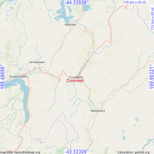
Cromwell GPS coordinates[2]
45° 2' 18.132" South, 169° 12' 0.288" East
| Map corner | latitude | longitude |
|---|---|---|
| Upper-left | -44.53936°, | 168.49696° |
| Center: | -45.03837°, | 169.20008° |
| Lower-right: | -45.53306°, | 169.90321° |
| Map W x H: | 110.5×110.5 km | = 68.7×68.7mi |
| max Lat: | -34.99604° ⇑88.4% North |
| Cromwell: | -45.03837° |
| min Lat: | ⇓11.6% South -46.6° |
| min Long | Cromwell | max Long |
| -176.55973° | 169.20008° | 178.33333° |
| W 7.7%⇐ | ⇒92.3% E |
Elevation
Elevation of Cromwell is 212 m = 696 ft, and this is 127.6 m = 419 ft above average elevation for this country.
| Max E: |
819 m = 2687 ft | 11.6% |
| Cromwell | 212 m 696 ft | |
| Avg. | 84.4 m = 277 ft | |
Min E: |
3 m = 10 ft | 88.4% |
See also: New Zealand elevation on elevation.city.
Geographical zone
Cromwell is located in South temperate zone (between Tropic of Capricorn and the Antarctic Circle). Distance of this South polar circle is 2393.4 km =1487.2 mi to South.| Distance of | km | miles | from Cromwell |
|---|---|---|---|
| Equator | 5007.8 | 3111.7 | to North |
| Tropic Capricorn | 2401.9 | 1492.5 | to North |
| Antarctic Circle | 2393.4 | 1487.2 | to South |
| South Pole | 4999.3 | 3106.4 | to South |


Nearby cities:
15 places around Cromwell: (largest is in red/bold)
• Arrowtown
32.6 km =20.3 mi,  289°
289°
• Balclutha
139.6 km =86.7 mi,  162°
162°
• Clyde
18.8 km =11.7 mi,  151°
151°
• Dunedin
137.7 km =85.6 mi,  132°
132°
• Gore
120 km =74.6 mi,  189°
189°
• Kingston
50.2 km =31.2 mi,  229°
229°
• Milton
134.4 km =83.5 mi, 153°
• Oamaru
139.2 km =86.5 mi,  92°
92°
• Outram
122.4 km =76.1 mi,  138°
138°
• Queenstown
42.2 km =26.2 mi,  271°
271°
• Ranfurly
71.4 km =44.4 mi,  98°
98°
• Roxburgh
56.6 km =35.2 mi,  170°
170°
• Te Anau
123.5 km =76.7 mi,  250°
250°
• Waitati
132.8 km =82.5 mi, 126°
• Wanaka
37.8 km =23.5 mi,  354°
354°
Sources, notices
• [Note1] Compared only with cities in New Zealand existing in our database
• [Src1] Map data: © OpenStreetMap contributors (CC-BY-SA)
• [Src2] Other city data from geonames.org with taken over terms of usage.
• [Src3] Geographical zone / Annual Mean Temperature by Robert A. Rohde @ Wikipedia
