Clyde geodata
Clyde (Otago) is a populated place; located in New Zealand in Pacific/Auckland (GMT+12) time zone. With population of 890 people, there are 148 cities with bigger population in this country. Compared to other cities in New Zealand, 89.9% of cities are located further ↑North; 91.3% of cities are located further →East and 84.5% of cities have lower elevation than Clyde. Note1


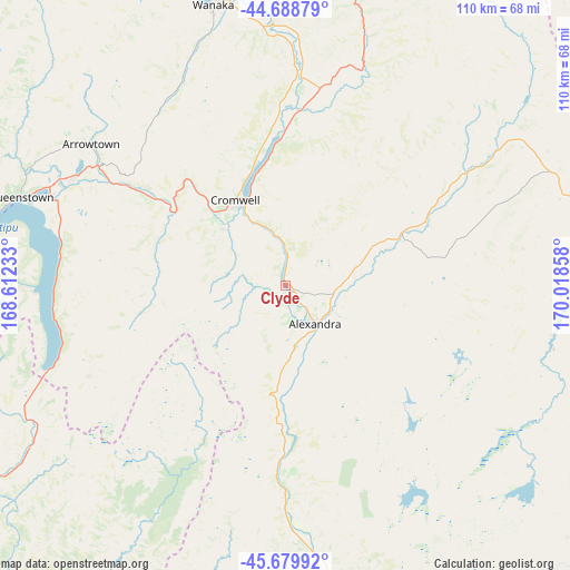
Clyde GPS coordinates[2]
45° 11' 11.436" South, 169° 18' 55.62" East
| Map corner | latitude | longitude |
|---|---|---|
| Upper-left | -44.68879°, | 168.61233° |
| Center: | -45.18651°, | 169.31545° |
| Lower-right: | -45.67992°, | 170.01858° |
| Map W x H: | 110.2×110.2 km | = 68.5×68.5mi |
| max Lat: | -34.99604° ⇑89.9% North |
| Clyde: | -45.18651° |
| min Lat: | ⇓10.1% South -46.6° |
| min Long | Clyde | max Long |
| -176.55973° | 169.31545° | 178.33333° |
| W 8.7%⇐ | ⇒91.3% E |
Elevation
Elevation of Clyde is 167 m = 548 ft, and this is 82.6 m = 271 ft above average elevation for this country.
| Max E: |
819 m = 2687 ft | 15.5% |
| Clyde | 167 m 548 ft | |
| Avg. | 84.4 m = 277 ft | |
Min E: |
3 m = 10 ft | 84.5% |
See also: New Zealand elevation on elevation.city.
Geographical zone
Clyde is located in South temperate zone (between Tropic of Capricorn and the Antarctic Circle). Distance of this South polar circle is 2376.9 km =1476.9 mi to South.| Distance of | km | miles | from Clyde |
|---|---|---|---|
| Equator | 5024.3 | 3122 | to North |
| Tropic Capricorn | 2418.3 | 1502.7 | to North |
| Antarctic Circle | 2376.9 | 1476.9 | to South |
| South Pole | 4982.8 | 3096.2 | to South |


Nearby cities:
15 places around Clyde: (largest is in red/bold)
• Arrowtown
48.3 km =30 mi,  304°
304°
• Balclutha
121.2 km =75.3 mi,  163°
163°
• Cromwell
18.8 km =11.7 mi,  331°
331°
• Dunedin
120 km =74.6 mi,  129°
129°
• Gore
105.9 km =65.8 mi,  195°
195°
• Kingston
49.8 km =30.9 mi,  250°
250°
• Milton
115.7 km =71.9 mi,  153°
153°
• Outram
104.1 km =64.7 mi,  136°
136°
• Portobello
127.5 km =79.2 mi, 125°
• Queenstown
54.1 km =33.6 mi,  288°
288°
• Ranfurly
61.8 km =38.4 mi,  84°
84°
• Roxburgh
39.4 km =24.5 mi,  180°
180°
• Te Anau
127.6 km =79.3 mi,  258°
258°
• Waitati
116 km =72.1 mi,  122°
122°
• Wanaka
55.6 km =34.5 mi,  346°
346°
Sources, notices
• [Note1] Compared only with cities in New Zealand existing in our database
• [Src1] Map data: © OpenStreetMap contributors (CC-BY-SA)
• [Src2] Other city data from geonames.org with taken over terms of usage.
• [Src3] Geographical zone / Annual Mean Temperature by Robert A. Rohde @ Wikipedia
