Queenstown geodata
Queenstown (Otago) is a populated place; located in New Zealand in Pacific/Auckland (GMT+13) time zone. With population of 10,442 people, there are 41 cities with bigger population in this country. Compared to other cities in New Zealand, 87.9% of cities are located further ↑North; 95.7% of cities are located further →East and 95.2% of cities have lower elevation than Queenstown. Note1


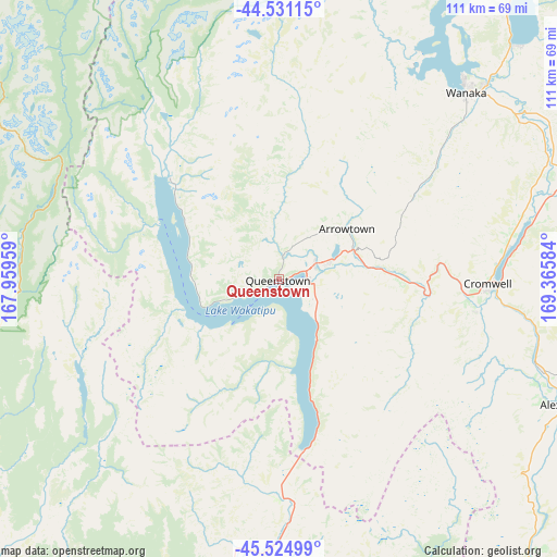
Queenstown GPS coordinates[2]
45° 1' 48.828" South, 168° 39' 45.756" East
| Map corner | latitude | longitude |
|---|---|---|
| Upper-left | -44.53115°, | 167.95959° |
| Center: | -45.03023°, | 168.66271° |
| Lower-right: | -45.52499°, | 169.36584° |
| Map W x H: | 110.5×110.5 km | = 68.7×68.7mi |
| max Lat: | -34.99604° ⇑87.9% North |
| Queenstown: | -45.03023° |
| min Lat: | ⇓12.1% South -46.6° |
| min Long | Queenstown | max Long |
| -176.55973° | 168.66271° | 178.33333° |
| W 4.3%⇐ | ⇒95.7% E |
Elevation
Elevation of Queenstown is 328 m = 1076 ft, and this is 243.6 m = 799 ft above average elevation for this country.
| Max E: |
819 m = 2687 ft | 4.8% |
| Queenstown | 328 m 1076 ft | |
| Avg. | 84.4 m = 277 ft | |
Min E: |
3 m = 10 ft | 95.2% |
See also: New Zealand elevation on elevation.city.
Geographical zone
Queenstown is located in South temperate zone (between Tropic of Capricorn and the Antarctic Circle). Distance of this South polar circle is 2394.3 km =1487.7 mi to South.| Distance of | km | miles | from Queenstown |
|---|---|---|---|
| Equator | 5006.9 | 3111.1 | to North |
| Tropic Capricorn | 2401 | 1491.9 | to North |
| Antarctic Circle | 2394.3 | 1487.7 | to South |
| South Pole | 5000.2 | 3107 | to South |


Nearby cities:
15 places around Queenstown: (largest is in red/bold)
• Arrowtown
15.4 km =9.6 mi,  48°
48°
• Clyde
54.1 km =33.6 mi,  108°
108°
• Cromwell
42.2 km =26.2 mi,  91°
91°
• Edendale
143.3 km =89 mi,  176°
176°
• Gore
121.2 km =75.3 mi,  169°
169°
• Kingston
33.9 km =21.1 mi, 173°
• Otautau
134.8 km =83.8 mi,  202°
202°
• Ranfurly
113.4 km =70.5 mi,  95°
95°
• Roxburgh
76.3 km =47.4 mi,  138°
138°
• Te Anau
85.6 km =53.2 mi,  239°
239°
• Tuatapere
144.4 km =89.7 mi,  211°
211°
• Wallacetown
147.9 km =91.9 mi,  191°
191°
• Wanaka
53.1 km =33 mi, 46°
• Winton
127.1 km =79 mi, 191°
• Wyndham
145.6 km =90.5 mi, 174°
Sources, notices
• [Note1] Compared only with cities in New Zealand existing in our database
• [Src1] Map data: © OpenStreetMap contributors (CC-BY-SA)
• [Src2] Other city data from geonames.org with taken over terms of usage.
• [Src3] Geographical zone / Annual Mean Temperature by Robert A. Rohde @ Wikipedia
