Portobello geodata
Portobello (Otago) is a populated place; located in New Zealand in Pacific/Auckland (GMT+13) time zone. With population of 1,200 people, there are 129 cities with bigger population in this country. Compared to other cities in New Zealand, 92.3% of cities are located further ↑North; 87% of cities are located further →East and 71% of cities have lower elevation than Portobello. Note1


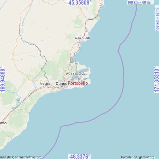
Portobello GPS coordinates[2]
45° 51' 0" South, 170° 39' 0" East
| Map corner | latitude | longitude |
|---|---|---|
| Upper-left | -45.35809°, | 169.94688° |
| Center: | -45.85°, | 170.65° |
| Lower-right: | -46.3376°, | 171.35313° |
| Map W x H: | 108.9×108.9 km | = 67.7×67.7mi |
| max Lat: | -34.99604° ⇑92.3% North |
| Portobello: | -45.85° |
| min Lat: | ⇓7.7% South -46.6° |
| min Long | Portobello | max Long |
| -176.55973° | 170.65° | 178.33333° |
| W 13%⇐ | ⇒87% E |
Elevation
Elevation of Portobello is 77 m = 253 ft, and this is 7.4 m = 24 ft below average elevation for this country.
| Max E: |
819 m = 2687 ft | 29% |
| Avg. | 84.4 m = 277 ft | |
| Portobello | 77 m = 253 ft | |
Min E: |
3 m = 10 ft | 71% |
See also: New Zealand elevation on elevation.city.
Geographical zone
Portobello is located in South temperate zone (between Tropic of Capricorn and the Antarctic Circle). Distance of this South polar circle is 2303.1 km =1431.1 mi to South.| Distance of | km | miles | from Portobello |
|---|---|---|---|
| Equator | 5098 | 3167.7 | to North |
| Tropic Capricorn | 2492.1 | 1548.5 | to North |
| Antarctic Circle | 2303.1 | 1431.1 | to South |
| South Pole | 4909 | 3050.3 | to South |


Nearby cities:
15 places around Portobello: (largest is in red/bold)
• Balclutha
81.5 km =50.6 mi,  238°
238°
• Clyde
127.5 km =79.2 mi,  305°
305°
• Cromwell
144.7 km =89.9 mi, 308°
• Dunedin
11.6 km =7.2 mi,  256°
256°
• Edendale
153 km =95.1 mi,  250°
250°
• Gore
134.8 km =83.8 mi, 257°
• Kaitangata
77.7 km =48.3 mi,  232°
232°
• Milton
60.6 km =37.7 mi, 240°
• Oamaru
87.3 km =54.2 mi,  16°
16°
• Outram
32.3 km =20.1 mi,  266°
266°
• Papatowai
120.3 km =74.8 mi, 228°
• Ranfurly
90.5 km =56.2 mi,  331°
331°
• Roxburgh
109.3 km =67.9 mi,  288°
288°
• Waitati
12.9 km =8 mi, 329°
• Wyndham
148.8 km =92.5 mi, 248°
Sources, notices
• [Note1] Compared only with cities in New Zealand existing in our database
• [Src1] Map data: © OpenStreetMap contributors (CC-BY-SA)
• [Src2] Other city data from geonames.org with taken over terms of usage.
• [Src3] Geographical zone / Annual Mean Temperature by Robert A. Rohde @ Wikipedia
