Dunedin geodata
Dunedin (Otago) is a seat of a first-order administrative division; located in New Zealand in Pacific/Auckland (GMT+12) time zone. With population of 114,347 people, there are 7 cities with bigger population in this country. Compared to other cities in New Zealand, 93.2% of cities are located further ↑North; 87.9% of cities are located further →East and 61.4% of cities have higher elevation than Dunedin. Note1


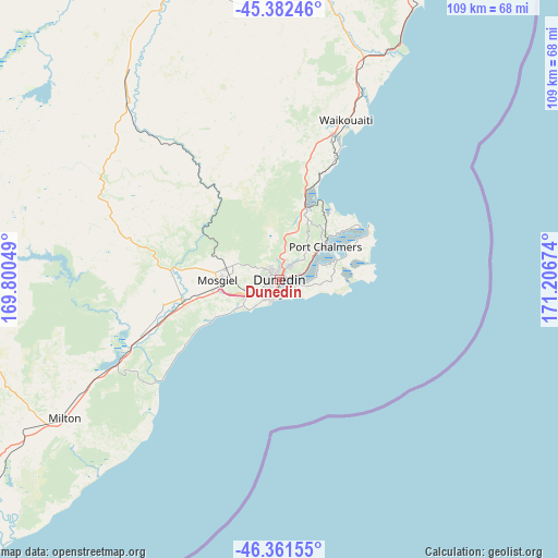
Dunedin GPS coordinates[2]
45° 52' 26.976" South, 170° 30' 12.996" East
| Map corner | latitude | longitude |
|---|---|---|
| Upper-left | -45.38246°, | 169.80049° |
| Center: | -45.87416°, | 170.50361° |
| Lower-right: | -46.36155°, | 171.20674° |
| Map W x H: | 108.9×108.9 km | = 67.7×67.7mi |
| max Lat: | -34.99604° ⇑93.2% North |
| Dunedin: | -45.87416° |
| min Lat: | ⇓6.8% South -46.6° |
| min Long | Dunedin | max Long |
| -176.55973° | 170.50361° | 178.33333° |
| W 12.1%⇐ | ⇒87.9% E |
Elevation
Elevation of Dunedin is 21 m = 69 ft, and this is 63.4 m = 208 ft below average elevation for this country.
| Max E: |
819 m = 2687 ft | 61.4% |
| Avg. | 84.4 m = 277 ft | |
| Dunedin | 21 m = 69 ft | |
Min E: |
3 m = 10 ft | 38.6% |
See also: Dunedin elevation on elevation.city.
Geographical zone
Dunedin is located in South temperate zone (between Tropic of Capricorn and the Antarctic Circle). Distance of this South polar circle is 2300.4 km =1429.4 mi to South.| Distance of | km | miles | from Dunedin |
|---|---|---|---|
| Equator | 5100.7 | 3169.4 | to North |
| Tropic Capricorn | 2494.8 | 1550.2 | to North |
| Antarctic Circle | 2300.4 | 1429.4 | to South |
| South Pole | 4906.3 | 3048.6 | to South |


Nearby cities:
15 places around Dunedin: (largest is in red/bold)
• Balclutha
70.6 km =43.9 mi,  235°
235°
• Clyde
120 km =74.6 mi,  309°
309°
• Cromwell
137.7 km =85.6 mi, 312°
• Edendale
141.5 km =87.9 mi,  249°
249°
• Gore
123.2 km =76.6 mi,  258°
258°
• Kaitangata
67.3 km =41.8 mi,  228°
228°
• Milton
49.5 km =30.8 mi, 236°
• Oamaru
93.7 km =58.2 mi,  22°
22°
• Outram
20.9 km =13 mi,  272°
272°
• Papatowai
110.2 km =68.5 mi, 226°
• Portobello
11.6 km =7.2 mi,  76°
76°
• Ranfurly
88.2 km =54.8 mi,  339°
339°
• Roxburgh
99.5 km =61.8 mi,  291°
291°
• Waitati
14.6 km =9.1 mi, 19°
• Wyndham
137.3 km =85.3 mi, 248°
Sources, notices
• [Note1] Compared only with cities in New Zealand existing in our database
• [Src1] Map data: © OpenStreetMap contributors (CC-BY-SA)
• [Src2] Other city data from geonames.org with taken over terms of usage.
• [Src3] Geographical zone / Annual Mean Temperature by Robert A. Rohde @ Wikipedia
