Whakatane geodata
Whakatane (Bay of Plenty) is a seat of a first-order administrative division; located in New Zealand in Pacific/Auckland (GMT+12) time zone. With population of 18,602 people, there are 32 cities with bigger population in this country. Compared to other cities in New Zealand, 66.7% of cities are located further ↓South; 95.7% of cities are located further ←West and 78.3% of cities have higher elevation than Whakatane. Note1


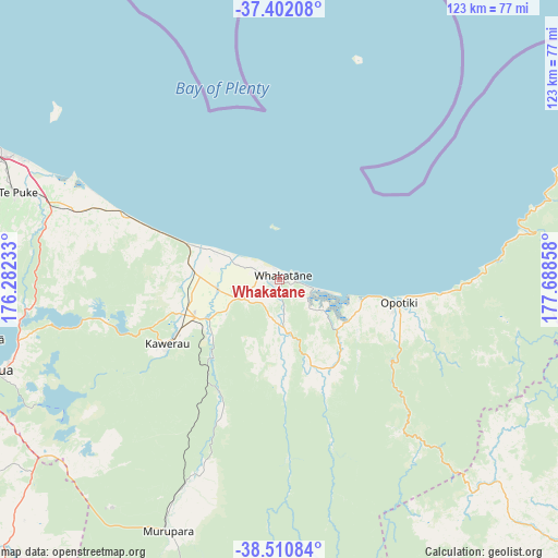
Whakatane GPS coordinates[2]
37° 57' 30.78" South, 176° 59' 7.62" East
| Map corner | latitude | longitude |
|---|---|---|
| Upper-left | -37.40208°, | 176.28233° |
| Center: | -37.95855°, | 176.98545° |
| Lower-right: | -38.51084°, | 177.68858° |
| Map W x H: | 123.3×123.3 km | = 76.6×76.6mi |
| max Lat: | -34.99604° ⇑33.3% North |
| Whakatane: | -37.95855° |
| min Lat: | ⇓66.7% South -46.6° |
| min Long | Whakatane | max Long |
| -176.55973° | 176.98545° | 178.33333° |
| W 95.7%⇐ | ⇒4.3% E |
Elevation
Elevation of Whakatane is 11 m = 36 ft, and this is 73.4 m = 241 ft below average elevation for this country.
| Max E: |
819 m = 2687 ft | 78.3% |
| Avg. | 84.4 m = 277 ft | |
| Whakatane | 11 m = 36 ft | |
Min E: |
3 m = 10 ft | 21.7% |
See also: New Zealand elevation on elevation.city.
Geographical zone
Whakatane is located in South temperate zone (between Tropic of Capricorn and the Antarctic Circle). Distance of this Southern Tropic circle is 1614.7 km =1003.3 mi to North.| Distance of | km | miles | from Whakatane |
|---|---|---|---|
| Equator | 4220.6 | 2622.6 | to North |
| Tropic Capricorn | 1614.7 | 1003.3 | to North |
| Antarctic Circle | 3180.6 | 1976.3 | to South |
| South Pole | 5786.5 | 3595.6 | to South |


Nearby cities:
15 places around Whakatane: (largest is in red/bold)
• Edgecumbe
13.6 km =8.5 mi,  258°
258°
• Kawerau
29.5 km =18.3 mi,  237°
237°
• Maketu
51.6 km =32.1 mi,  294°
294°
• Mamaku
80.6 km =50.1 mi, 258°
• Matata
22.3 km =13.9 mi, 292°
• Murupara
61.8 km =38.4 mi,  203°
203°
• Opotiki
27 km =16.8 mi,  102°
102°
• Paengaroa
52.3 km =32.5 mi, 287°
• Reporoa
77.4 km =48.1 mi,  226°
226°
• Rotorua
67.8 km =42.1 mi,  252°
252°
• Taneatua
12.3 km =7.6 mi,  167°
167°
• Tauranga
78 km =48.5 mi, 292°
• Te Karaka
95.5 km =59.3 mi,  126°
126°
• Tokoroa
102.6 km =63.8 mi, 252°
• Waimana
22.9 km =14.2 mi,  158°
158°
Sources, notices
• [Note1] Compared only with cities in New Zealand existing in our database
• [Src1] Map data: © OpenStreetMap contributors (CC-BY-SA)
• [Src2] Other city data from geonames.org with taken over terms of usage.
• [Src3] Geographical zone / Annual Mean Temperature by Robert A. Rohde @ Wikipedia
