Caballero geodata
Caballero (Coclé) is a seat of a third-order administrative division; located in Panama in America/Panama (GMT-5) time zone. With population of 114 people, there are 649 cities with bigger population in this country. Compared to other cities in Panama, 58.6% of cities are located further ↓South; 67.3% of cities are located further ←West and 82.9% of cities have lower elevation than Caballero. Note1


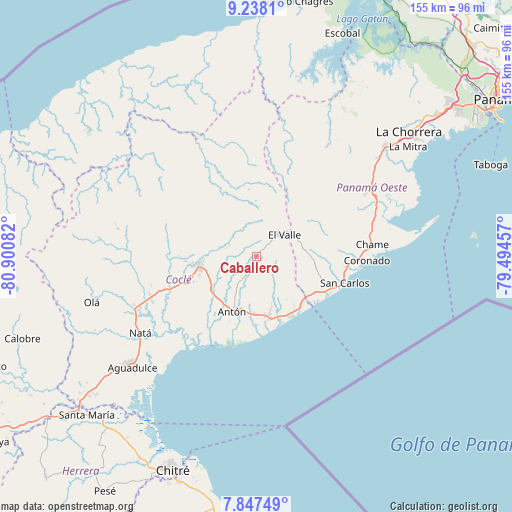
Caballero GPS coordinates[2]
8° 32' 36.348" North, 80° 11' 51.684" West
| Map corner | latitude | longitude |
|---|---|---|
| Upper-left | 9.2381°, | -80.90082° |
| Center: | 8.54343°, | -80.19769° |
| Lower-right: | 7.84749°, | -79.49457° |
| Map W x H: | 154.6×154.6 km | = 96.1×96.1mi |
| max Lat: | 9.60898° ⇑41.4% North |
| Caballero: | 8.54343° |
| min Lat: | ⇓58.6% South 7.26534° |
| min Long | Caballero | max Long |
| -82.91275° | -80.19769° | -77.38965° |
| W 67.3%⇐ | ⇒32.7% E |
Elevation
Elevation of Caballero is 304 m = 997 ft, and this is 131.9 m = 433 ft above average elevation for this country.
| Max E: |
2103 m = 6900 ft | 17.1% |
| Caballero | 304 m 997 ft | |
| Avg. | 172.1 m = 565 ft | |
Min E: |
-1 m = -3 ft | 82.9% |
See also: Panama elevation on elevation.city.
Geographical zone
Caballero is located in North Torrid zone (between Equator and Tropic of Cancer). Distance of Equator is 949.9 km =590.2 mi to South.| Distance of | km | miles | from Caballero |
|---|---|---|---|
| North Pole | 9057.1 | 5627.8 | to North |
| Arctic Circle | 6451.2 | 4008.6 | to North |
| Tropic Cancer | 1656 | 1029 | to North |
| Equator | 949.9 | 590.2 | to South |


Nearby cities:
15 places around Caballero: (largest is in red/bold)
• Alto de La Estancia
5.2 km =3.2 mi,  16°
16°
• Cabuya
3.3 km =2.1 mi,  83°
83°
• Caimito
9.9 km =6.2 mi,  332°
332°
• Churuquita Chiquita
8.9 km =5.5 mi,  293°
293°
• Churuquita Grande
9.9 km =6.2 mi,  304°
304°
• El Retiro
8.5 km =5.3 mi,  145°
145°
• Entradero
3 km =1.9 mi,  339°
339°
• Llano Grande
10.8 km =6.7 mi,  197°
197°
• Membrillo
4.6 km =2.9 mi, 338°
• Pajonal Abajo
8.1 km =5 mi, 304°
• Rincón de Las Palmas
5.9 km =3.7 mi,  283°
283°
• San Juan de Dios
3.3 km =2.1 mi, 285°
• Santa Rita
5.8 km =3.6 mi,  163°
163°
• Sofre
8.3 km =5.2 mi,  345°
345°
• Turega
7.7 km =4.8 mi,  2°
2°
Sources, notices
• [Note1] Compared only with cities in Panama existing in our database
• [Src1] Map data: © OpenStreetMap contributors (CC-BY-SA)
• [Src2] Other city data from geonames.org with taken over terms of usage.
• [Src3] Geographical zone / Annual Mean Temperature by Robert A. Rohde @ Wikipedia
