Entradero geodata
Entradero (Coclé) is a populated place; located in Panama in America/Panama (GMT-5) time zone. With population of 1,049 people, there are 244 cities with bigger population in this country. Compared to other cities in Panama, 61.5% of cities are located further ↓South; 66.9% of cities are located further ←West and 85.9% of cities have lower elevation than Entradero. Note1


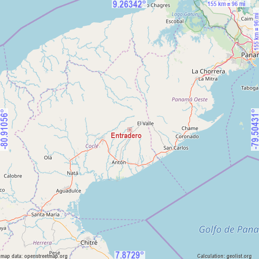
Entradero GPS coordinates[2]
8° 34' 7.68" North, 80° 12' 26.748" West
| Map corner | latitude | longitude |
|---|---|---|
| Upper-left | 9.26342°, | -80.91056° |
| Center: | 8.5688°, | -80.20743° |
| Lower-right: | 7.8729°, | -79.50431° |
| Map W x H: | 154.6×154.6 km | = 96.1×96.1mi |
| max Lat: | 9.60898° ⇑38.5% North |
| Entradero: | 8.5688° |
| min Lat: | ⇓61.5% South 7.26534° |
| min Long | Entradero | max Long |
| -82.91275° | -80.20743° | -77.38965° |
| W 66.9%⇐ | ⇒33.1% E |
Elevation
Elevation of Entradero is 346 m = 1135 ft, and this is 173.9 m = 571 ft above average elevation for this country.
| Max E: |
2103 m = 6900 ft | 14.1% |
| Entradero | 346 m 1135 ft | |
| Avg. | 172.1 m = 565 ft | |
Min E: |
-1 m = -3 ft | 85.9% |
See also: Panama elevation on elevation.city.
Geographical zone
Entradero is located in North Torrid zone (between Equator and Tropic of Cancer). Distance of Equator is 952.8 km =592 mi to South.| Distance of | km | miles | from Entradero |
|---|---|---|---|
| North Pole | 9054.3 | 5626.1 | to North |
| Arctic Circle | 6448.4 | 4006.8 | to North |
| Tropic Cancer | 1653.2 | 1027.3 | to North |
| Equator | 952.8 | 592 | to South |


Nearby cities:
15 places around Entradero: (largest is in red/bold)
• Alto de La Estancia
3.3 km =2.1 mi,  49°
49°
• Caballero
3 km =1.9 mi,  159°
159°
• Cabuya
5 km =3.1 mi,  118°
118°
• Caimito
6.9 km =4.3 mi,  329°
329°
• Churuquita Chiquita
7.1 km =4.4 mi,  276°
276°
• Churuquita Grande
7.6 km =4.7 mi,  291°
291°
• El Retiro
11.5 km =7.1 mi,  149°
149°
• Membrillo
1.6 km =1 mi,  337°
337°
• Miraflores
9.9 km =6.2 mi,  309°
309°
• Pajonal Abajo
5.9 km =3.7 mi, 288°
• Rincón de Las Palmas
4.9 km =3 mi,  252°
252°
• San Juan de Dios
2.8 km =1.7 mi,  226°
226°
• Santa Rita
8.8 km =5.5 mi, 162°
• Sofre
5.3 km =3.3 mi,  348°
348°
• Turega
5 km =3.1 mi,  16°
16°
Sources, notices
• [Note1] Compared only with cities in Panama existing in our database
• [Src1] Map data: © OpenStreetMap contributors (CC-BY-SA)
• [Src2] Other city data from geonames.org with taken over terms of usage.
• [Src3] Geographical zone / Annual Mean Temperature by Robert A. Rohde @ Wikipedia
