Cabuya geodata
Cabuya (Coclé) is a seat of a third-order administrative division; located in Panama in America/Panama (GMT-5) time zone. With population of 93 people, there are 659 cities with bigger population in this country. Compared to other cities in Panama, 59.1% of cities are located further ↓South; 69% of cities are located further ←West and 87.7% of cities have lower elevation than Cabuya. Note1


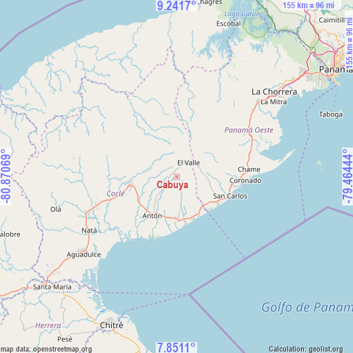
Cabuya GPS coordinates[2]
8° 32' 49.308" North, 80° 10' 3.216" West
| Map corner | latitude | longitude |
|---|---|---|
| Upper-left | 9.2417°, | -80.87069° |
| Center: | 8.54703°, | -80.16756° |
| Lower-right: | 7.8511°, | -79.46444° |
| Map W x H: | 154.6×154.6 km | = 96.1×96.1mi |
| max Lat: | 9.60898° ⇑40.9% North |
| Cabuya: | 8.54703° |
| min Lat: | ⇓59.1% South 7.26534° |
| min Long | Cabuya | max Long |
| -82.91275° | -80.16756° | -77.38965° |
| W 69%⇐ | ⇒31% E |
Elevation
Elevation of Cabuya is 391 m = 1283 ft, and this is 218.9 m = 718 ft above average elevation for this country.
| Max E: |
2103 m = 6900 ft | 12.3% |
| Cabuya | 391 m 1283 ft | |
| Avg. | 172.1 m = 565 ft | |
Min E: |
-1 m = -3 ft | 87.7% |
See also: Panama elevation on elevation.city.
Geographical zone
Cabuya is located in North Torrid zone (between Equator and Tropic of Cancer). Distance of Equator is 950.3 km =590.5 mi to South.| Distance of | km | miles | from Cabuya |
|---|---|---|---|
| North Pole | 9056.7 | 5627.6 | to North |
| Arctic Circle | 6450.8 | 4008.3 | to North |
| Tropic Cancer | 1655.6 | 1028.7 | to North |
| Equator | 950.3 | 590.5 | to South |


Nearby cities:
15 places around Cabuya: (largest is in red/bold)
• Alto de La Estancia
4.9 km =3 mi,  337°
337°
• Caballero
3.3 km =2.1 mi,  263°
263°
• Caimito
11.5 km =7.1 mi,  316°
316°
• El Retiro
7.6 km =4.7 mi,  168°
168°
• Entradero
5 km =3.1 mi,  298°
298°
• Las Colinas
9.3 km =5.8 mi,  87°
87°
• Los Llanitos
9.8 km =6.1 mi,  54°
54°
• Mata Ahogado
11.2 km =7 mi, 45°
• Membrillo
6.3 km =3.9 mi,  307°
307°
• Pajonal Abajo
10.8 km =6.7 mi,  293°
293°
• Rincón de Las Palmas
9.1 km =5.7 mi,  275°
275°
• San Juan de Dios
6.5 km =4 mi,  274°
274°
• Santa Rita
6.2 km =3.9 mi,  195°
195°
• Sofre
9.3 km =5.8 mi, 324°
• Turega
7.8 km =4.8 mi, 337°
Sources, notices
• [Note1] Compared only with cities in Panama existing in our database
• [Src1] Map data: © OpenStreetMap contributors (CC-BY-SA)
• [Src2] Other city data from geonames.org with taken over terms of usage.
• [Src3] Geographical zone / Annual Mean Temperature by Robert A. Rohde @ Wikipedia
