Taboga geodata
Taboga (Panamá) is a populated place; located in Panama in America/Panama (GMT-5) time zone. With population of 722 people, there are 346 cities with bigger population in this country. Compared to other cities in Panama, 73.4% of cities are located further ↓South; 86.1% of cities are located further ←West and 99.9% of cities have higher elevation than Taboga. Note1


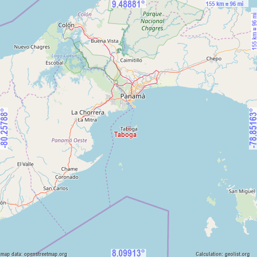
Taboga GPS coordinates[2]
8° 47' 40.632" North, 79° 33' 17.1" West
| Map corner | latitude | longitude |
|---|---|---|
| Upper-left | 9.48881°, | -80.25788° |
| Center: | 8.79462°, | -79.55475° |
| Lower-right: | 8.09913°, | -78.85163° |
| Map W x H: | 154.5×154.5 km | = 96×96mi |
| max Lat: | 9.60898° ⇑26.6% North |
| Taboga: | 8.79462° |
| min Lat: | ⇓73.4% South 7.26534° |
| min Long | Taboga | max Long |
| -82.91275° | -79.55475° | -77.38965° |
| W 86.1%⇐ | ⇒13.9% E |
Elevation
Elevation of Taboga is 0 m = 0 ft, and this is 172.1 m = 565 ft below average elevation for this country.
| Max E: |
2103 m = 6900 ft | 99.9% |
| Avg. | 172.1 m = 565 ft | |
| Taboga | 0 m = 0 ft | |
Min E: |
-1 m = -3 ft | 0.1% |
See also: Panama elevation on elevation.city.
Geographical zone
Taboga is located in North Torrid zone (between Equator and Tropic of Cancer). Distance of Equator is 977.9 km =607.6 mi to South.| Distance of | km | miles | from Taboga |
|---|---|---|---|
| North Pole | 9029.2 | 5610.5 | to North |
| Arctic Circle | 6423.3 | 3991.3 | to North |
| Tropic Cancer | 1628 | 1011.6 | to North |
| Equator | 977.9 | 607.6 | to South |


Nearby cities:
15 places around Taboga: (largest is in red/bold)
• Ancón
18.4 km =11.4 mi,  1°
1°
• Arraiján
21 km =13 mi,  326°
326°
• Balboa
17.1 km =10.6 mi,  355°
355°
• Cerro El Castillo
23 km =14.3 mi,  323°
323°
• Curundú
19.6 km =12.2 mi, 2°
• El Chorrillo
17.3 km =10.7 mi, 2°
• Howard
16.6 km =10.3 mi,  346°
346°
• Monte Claro
19.4 km =12.1 mi, 320°
• Nuevo Arraiján
23.2 km =14.4 mi,  308°
308°
• Panamá
22.5 km =14 mi,  9°
9°
• Puerto Caimito
19.4 km =12.1 mi,  295°
295°
• San Felipe
17.5 km =10.9 mi, 6°
• San Vicente de Bique
18.4 km =11.4 mi, 314°
• Veracruz
13.2 km =8.2 mi, 323°
• Vista Alegre
22 km =13.7 mi, 312°
Sources, notices
• [Note1] Compared only with cities in Panama existing in our database
• [Src1] Map data: © OpenStreetMap contributors (CC-BY-SA)
• [Src2] Other city data from geonames.org with taken over terms of usage.
• [Src3] Geographical zone / Annual Mean Temperature by Robert A. Rohde @ Wikipedia
