San Felipe geodata
San Felipe (Panamá) is a section of populated place; located in Panama in America/Panama (GMT-5) time zone. With population of 3,262 people, there are 89 cities with bigger population in this country. Compared to other cities in Panama, 81.6% of cities are located further ↓South; 86.9% of cities are located further ←West and 94.7% of cities have higher elevation than San Felipe. Note1


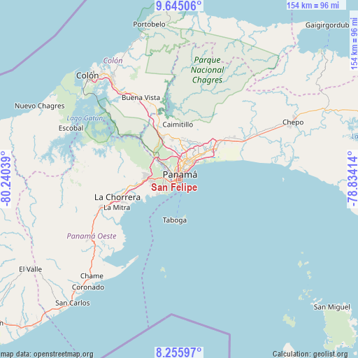
San Felipe GPS coordinates[2]
8° 57' 4.248" North, 79° 32' 14.136" West
| Map corner | latitude | longitude |
|---|---|---|
| Upper-left | 9.64506°, | -80.24039° |
| Center: | 8.95118°, | -79.53726° |
| Lower-right: | 8.25597°, | -78.83414° |
| Map W x H: | 154.5×154.5 km | = 96×96mi |
| max Lat: | 9.60898° ⇑18.4% North |
| San Felipe: | 8.95118° |
| min Lat: | ⇓81.6% South 7.26534° |
| min Long | San Felipe | max Long |
| -82.91275° | -79.53726° | -77.38965° |
| W 86.9%⇐ | ⇒13.1% E |
Elevation
Elevation of San Felipe is 8 m = 26 ft, and this is 164.1 m = 538 ft below average elevation for this country.
| Max E: |
2103 m = 6900 ft | 94.7% |
| Avg. | 172.1 m = 565 ft | |
| San Felipe | 8 m = 26 ft | |
Min E: |
-1 m = -3 ft | 5.3% |
See also: Panama elevation on elevation.city.
Geographical zone
San Felipe is located in North Torrid zone (between Equator and Tropic of Cancer). Distance of Equator is 995.3 km =618.5 mi to South.| Distance of | km | miles | from San Felipe |
|---|---|---|---|
| North Pole | 9011.8 | 5599.7 | to North |
| Arctic Circle | 6405.9 | 3980.4 | to North |
| Tropic Cancer | 1610.6 | 1000.8 | to North |
| Equator | 995.3 | 618.5 | to South |


Nearby cities:
15 places around San Felipe: (largest is in red/bold)
• Ancón
1.8 km =1.1 mi,  302°
302°
• Arraiján
13.5 km =8.4 mi,  270°
270°
• Balboa
3.3 km =2.1 mi,  264°
264°
• Curundú
2.4 km =1.5 mi,  336°
336°
• El Chorrillo
1.1 km =0.7 mi, 261°
• Howard
6 km =3.7 mi, 257°
• Juan Díaz
14.6 km =9.1 mi,  41°
41°
• Mocambo Arriba
14.1 km =8.8 mi,  346°
346°
• Monte Claro
14.6 km =9.1 mi, 260°
• Panamá
5.1 km =3.2 mi,  22°
22°
• Paraíso
13.5 km =8.4 mi,  312°
312°
• Parque Lefevre
9.4 km =5.8 mi, 39°
• Río Abajo
8.4 km =5.2 mi,  29°
29°
• San Miguelito
13.2 km =8.2 mi, 33°
• Veracruz
11.9 km =7.4 mi,  235°
235°
Sources, notices
• [Note1] Compared only with cities in Panama existing in our database
• [Src1] Map data: © OpenStreetMap contributors (CC-BY-SA)
• [Src2] Other city data from geonames.org with taken over terms of usage.
• [Src3] Geographical zone / Annual Mean Temperature by Robert A. Rohde @ Wikipedia
