Panamá geodata
Panamá is a capital of a political entity; located in Panama in America/Panama (GMT-5) time zone. With population of 408,168 people, there are 0 cities with bigger population in this country. Compared to other cities in Panama, 83.5% of cities are located further ↓South; 87.3% of cities are located further ←West and 85.5% of cities have higher elevation than Panamá. Note1


Panamá GPS coordinates[2]
8° 59' 36.96" North, 79° 31' 11.028" West
| Map corner | latitude | longitude |
|---|---|---|
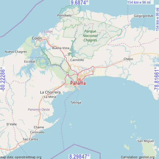
| Upper-left | 9.6874°, | -80.22286° |
| Center: | 8.9936°, | -79.51973° |
| Lower-right: | 8.29847°, | -78.81661° |
| Map W x H: | 154.4×154.4 km | = 95.9×95.9mi |
| max Lat: | 9.60898° ⇑16.5% North |
| Panamá: | 8.9936° |
| min Lat: | ⇓83.5% South 7.26534° |
| min Long | Panamá | max Long |
| -82.91275° | -79.51973° | -77.38965° |
| W 87.3%⇐ | ⇒12.7% E |
Elevation
Elevation of Panamá is 17 m = 56 ft, and this is 155.1 m = 509 ft below average elevation for this country.
| Max E: |
2103 m = 6900 ft | 85.5% |
| Avg. | 172.1 m = 565 ft | |
| Panamá | 17 m = 56 ft | |
Min E: |
-1 m = -3 ft | 14.5% |
See also: Panamá elevation on elevation.city.
Geographical zone
Panamá is located in North Torrid zone (between Equator and Tropic of Cancer). Distance of Equator is 1000 km =621.4 mi to South.| Distance of | km | miles | from Panamá |
|---|---|---|---|
| North Pole | 9007.1 | 5596.8 | to North |
| Arctic Circle | 6401.2 | 3977.5 | to North |
| Tropic Cancer | 1605.9 | 997.9 | to North |
| Equator | 1000 | 621.4 | to South |


Nearby cities:
15 places around Panamá: (largest is in red/bold)
• Ancón
5.1 km =3.2 mi,  223°
223°
• Balboa
7.2 km =4.5 mi,  225°
225°
• Curundú
3.8 km =2.4 mi, 228°
• El Chorrillo
5.7 km =3.5 mi,  211°
211°
• Gonzalillo
10.9 km =6.8 mi,  0°
0°
• Howard
9.9 km =6.2 mi, 232°
• Juan Díaz
9.9 km =6.2 mi,  50°
50°
• Las Cumbres
10.7 km =6.6 mi,  355°
355°
• Mocambo Arriba
10.4 km =6.5 mi,  329°
329°
• Paraíso
12.6 km =7.8 mi,  290°
290°
• Parque Lefevre
4.7 km =2.9 mi,  57°
57°
• Pedregal
12.5 km =7.8 mi, 49°
• Río Abajo
3.4 km =2.1 mi,  40°
40°
• San Felipe
5.1 km =3.2 mi,  202°
202°
• San Miguelito
8.3 km =5.2 mi, 40°
Sources, notices
• [Note1] Compared only with cities in Panama existing in our database
• [Src1] Map data: © OpenStreetMap contributors (CC-BY-SA)
• [Src2] Other city data from geonames.org with taken over terms of usage.
• [Src3] Geographical zone / Annual Mean Temperature by Robert A. Rohde @ Wikipedia
