Plaza de Caisán geodata
Plaza de Caisán (Chiriquí) is a seat of a third-order administrative division; located in Panama in America/Panama (GMT-5) time zone. With population of 1,363 people, there are 177 cities with bigger population in this country. Compared to other cities in Panama, 71.2% of cities are located further ↓South; 97.2% of cities are located further →East and 95.8% of cities have lower elevation than Plaza de Caisán. Note1


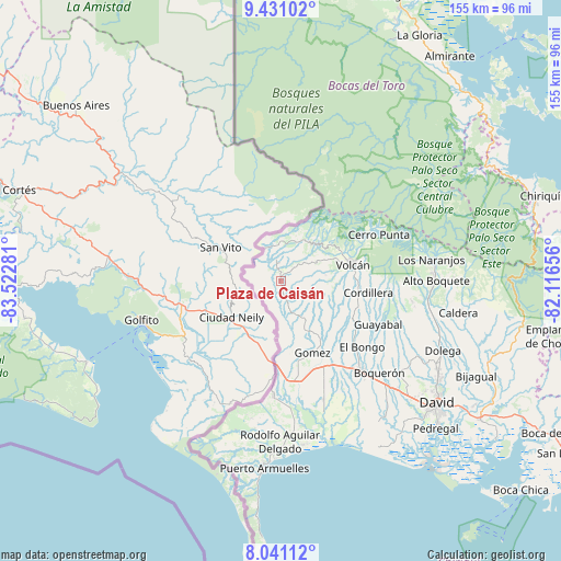
Plaza de Caisán GPS coordinates[2]
8° 44' 12.192" North, 82° 49' 10.848" West
| Map corner | latitude | longitude |
|---|---|---|
| Upper-left | 9.43102°, | -83.52281° |
| Center: | 8.73672°, | -82.81968° |
| Lower-right: | 8.04112°, | -82.11656° |
| Map W x H: | 154.5×154.5 km | = 96×96mi |
| max Lat: | 9.60898° ⇑28.8% North |
| Plaza de Caisán: | 8.73672° |
| min Lat: | ⇓71.2% South 7.26534° |
| min Long | Plaza de Caisá | max Long |
| -82.91275° | -82.81968° | -77.38965° |
| W 2.8%⇐ | ⇒97.2% E |
Elevation
Elevation of Plaza de Caisán is 792 m = 2598 ft, and this is 619.9 m = 2034 ft above average elevation for this country.
| Max E: |
2103 m = 6900 ft | 4.2% |
| Plaza de Caisán | 792 m 2598 ft | |
| Avg. | 172.1 m = 565 ft | |
Min E: |
-1 m = -3 ft | 95.8% |
See also: Panama elevation on elevation.city.
Geographical zone
Plaza de Caisán is located in North Torrid zone (between Equator and Tropic of Cancer). Distance of Equator is 971.4 km =603.6 mi to South.| Distance of | km | miles | from Plaza de Caisán |
|---|---|---|---|
| North Pole | 9035.6 | 5614.5 | to North |
| Arctic Circle | 6429.7 | 3995.2 | to North |
| Tropic Cancer | 1634.5 | 1015.6 | to North |
| Equator | 971.4 | 603.6 | to South |


Nearby cities:
15 places around Plaza de Caisán: (largest is in red/bold)
• Alto Quiel
8.8 km =5.5 mi,  264°
264°
• Breñón
12.5 km =7.8 mi,  176°
176°
• Cañas Gordas
10.3 km =6.4 mi,  273°
273°
• La Bonita
14.5 km =9 mi,  154°
154°
• Miraflores
12 km =7.5 mi,  355°
355°
• Monte Lirio
5.9 km =3.7 mi,  350°
350°
• Palmarito
9 km =5.6 mi, 356°
• Paso Canoas Arriba
19.1 km =11.9 mi, 180°
• Piedra Candela
17.6 km =10.9 mi,  24°
24°
• Portón
19.9 km =12.4 mi,  168°
168°
• Río Sereno
9.9 km =6.2 mi,  335°
335°
• San Andrés
18.1 km =11.2 mi, 145°
• San Francisco
15.2 km =9.4 mi,  138°
138°
• Santa Clara
11.7 km =7.3 mi, 22°
• Santa Cruz
12.4 km =7.7 mi, 147°
Sources, notices
• [Note1] Compared only with cities in Panama existing in our database
• [Src1] Map data: © OpenStreetMap contributors (CC-BY-SA)
• [Src2] Other city data from geonames.org with taken over terms of usage.
• [Src3] Geographical zone / Annual Mean Temperature by Robert A. Rohde @ Wikipedia
