Boquerón geodata
Boquerón (Chiriquí) is a seat of a second-order administrative division; located in Panama in America/Panama (GMT-5) time zone. With population of 1,658 people, there are 142 cities with bigger population in this country. Compared to other cities in Panama, 53.3% of cities are located further ↓South; 90.8% of cities are located further →East and 75.1% of cities have lower elevation than Boquerón. Note1


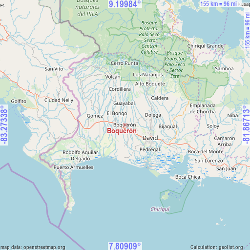
Boquerón GPS coordinates[2]
8° 30' 18.36" North, 82° 34' 12.9" West
| Map corner | latitude | longitude |
|---|---|---|
| Upper-left | 9.19984°, | -83.27338° |
| Center: | 8.5051°, | -82.57025° |
| Lower-right: | 7.80909°, | -81.86713° |
| Map W x H: | 154.6×154.6 km | = 96.1×96.1mi |
| max Lat: | 9.60898° ⇑46.7% North |
| Boquerón: | 8.5051° |
| min Lat: | ⇓53.3% South 7.26534° |
| min Long | Boquerón | max Long |
| -82.91275° | -82.57025° | -77.38965° |
| W 9.2%⇐ | ⇒90.8% E |
Elevation
Elevation of Boquerón is 202 m = 663 ft, and this is 29.9 m = 98 ft above average elevation for this country.
| Max E: |
2103 m = 6900 ft | 24.9% |
| Boquerón | 202 m 663 ft | |
| Avg. | 172.1 m = 565 ft | |
Min E: |
-1 m = -3 ft | 75.1% |
See also: Panama elevation on elevation.city.
Geographical zone
Boquerón is located in North Torrid zone (between Equator and Tropic of Cancer). Distance of Equator is 945.7 km =587.6 mi to South.| Distance of | km | miles | from Boquerón |
|---|---|---|---|
| North Pole | 9061.4 | 5630.5 | to North |
| Arctic Circle | 6455.5 | 4011.3 | to North |
| Tropic Cancer | 1660.2 | 1031.6 | to North |
| Equator | 945.7 | 587.6 | to South |


Nearby cities:
15 places around Boquerón: (largest is in red/bold)
• Bugaba
6 km =3.7 mi,  245°
245°
• Bugabita Arriba
7.5 km =4.7 mi,  284°
284°
• Bágala
6.7 km =4.2 mi,  133°
133°
• Chacarero
3.6 km =2.2 mi,  239°
239°
• El Tejar
8.4 km =5.2 mi,  182°
182°
• Guabal
8.5 km =5.3 mi,  25°
25°
• La Concepción
5.4 km =3.4 mi, 278°
• La Meseta
6 km =3.7 mi,  333°
333°
• Pueblo Nuevo
7.8 km =4.8 mi,  67°
67°
• San Carlos
6.8 km =4.2 mi,  79°
79°
• San Juan del Tejal
8.9 km =5.5 mi,  102°
102°
• San Miguel del Yuco
7.6 km =4.7 mi,  306°
306°
• San Pablo Viejo Arriba
7.7 km =4.8 mi,  111°
111°
• Tijeras
3.5 km =2.2 mi,  162°
162°
• Veladero
8 km =5 mi, 177°
Sources, notices
• [Note1] Compared only with cities in Panama existing in our database
• [Src1] Map data: © OpenStreetMap contributors (CC-BY-SA)
• [Src2] Other city data from geonames.org with taken over terms of usage.
• [Src3] Geographical zone / Annual Mean Temperature by Robert A. Rohde @ Wikipedia
