Cerro Viejo geodata
Cerro Viejo (Chiriquí) is a seat of a third-order administrative division; located in Panama in America/Panama (GMT-5) time zone. With population of 253 people, there are 574 cities with bigger population in this country. Compared to other cities in Panama, 69% of cities are located further ↑North; 71% of cities are located further →East and 89.5% of cities have lower elevation than Cerro Viejo. Note1


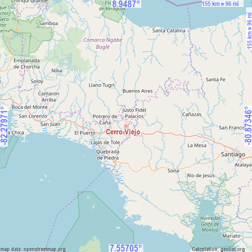
Cerro Viejo GPS coordinates[2]
8° 15' 12.564" North, 81° 34' 35.688" West
| Map corner | latitude | longitude |
|---|---|---|
| Upper-left | 8.9487°, | -82.27971° |
| Center: | 8.25349°, | -81.57658° |
| Lower-right: | 7.55705°, | -80.87346° |
| Map W x H: | 154.7×154.7 km | = 96.1×96.1mi |
| max Lat: | 9.60898° ⇑69% North |
| Cerro Viejo: | 8.25349° |
| min Lat: | ⇓31% South 7.26534° |
| min Long | Cerro Viejo | max Long |
| -82.91275° | -81.57658° | -77.38965° |
| W 29%⇐ | ⇒71% E |
Elevation
Elevation of Cerro Viejo is 434 m = 1424 ft, and this is 261.9 m = 859 ft above average elevation for this country.
| Max E: |
2103 m = 6900 ft | 10.5% |
| Cerro Viejo | 434 m 1424 ft | |
| Avg. | 172.1 m = 565 ft | |
Min E: |
-1 m = -3 ft | 89.5% |
See also: Panama elevation on elevation.city.
Geographical zone
Cerro Viejo is located in North Torrid zone (between Equator and Tropic of Cancer). Distance of Equator is 917.7 km =570.2 mi to South.| Distance of | km | miles | from Cerro Viejo |
|---|---|---|---|
| North Pole | 9089.4 | 5647.9 | to North |
| Arctic Circle | 6483.5 | 4028.7 | to North |
| Tropic Cancer | 1688.2 | 1049 | to North |
| Equator | 917.7 | 570.2 | to South |


Nearby cities:
15 places around Cerro Viejo: (largest is in red/bold)
• Alto Caballero
11.4 km =7.1 mi,  290°
290°
• Alto de Jesús
10.2 km =6.3 mi,  84°
84°
• Bajo Solis
11.7 km =7.3 mi,  26°
26°
• Bella Vista
7.2 km =4.5 mi,  223°
223°
• Cerro Caña
11.5 km =7.1 mi,  341°
341°
• Cerro Iglesias
7.4 km =4.6 mi,  10°
10°
• Cerro Pelado
10.9 km =6.8 mi,  157°
157°
• Cerro Venado
2.8 km =1.7 mi,  174°
174°
• El Piro
7.3 km =4.5 mi,  131°
131°
• El Prado
8.2 km =5.1 mi,  102°
102°
• Llano Limón
8.8 km =5.5 mi,  263°
263°
• Pueblo Viejo
9.5 km =5.9 mi,  268°
268°
• Tolé
10.6 km =6.6 mi, 261°
• Veladero
8.9 km =5.5 mi,  253°
253°
• Viguí
12.9 km =8 mi,  42°
42°
Sources, notices
• [Note1] Compared only with cities in Panama existing in our database
• [Src1] Map data: © OpenStreetMap contributors (CC-BY-SA)
• [Src2] Other city data from geonames.org with taken over terms of usage.
• [Src3] Geographical zone / Annual Mean Temperature by Robert A. Rohde @ Wikipedia
