Paraíso geodata
Paraíso (Panamá) is a populated place; located in Panama in America/Panama (GMT-5) time zone. With population of 833 people, there are 304 cities with bigger population in this country. Compared to other cities in Panama, 84.6% of cities are located further ↓South; 84.4% of cities are located further ←West and 52.4% of cities have higher elevation than Paraíso. Note1


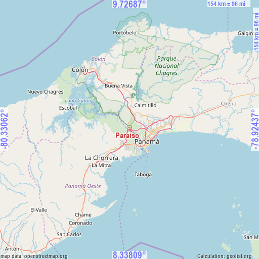
Paraíso GPS coordinates[2]
9° 1' 59.34" North, 79° 37' 38.964" West
| Map corner | latitude | longitude |
|---|---|---|
| Upper-left | 9.72687°, | -80.33062° |
| Center: | 9.03315°, | -79.62749° |
| Lower-right: | 8.33809°, | -78.92437° |
| Map W x H: | 154.4×154.4 km | = 95.9×95.9mi |
| max Lat: | 9.60898° ⇑15.4% North |
| Paraíso: | 9.03315° |
| min Lat: | ⇓84.6% South 7.26534° |
| min Long | Paraíso | max Long |
| -82.91275° | -79.62749° | -77.38965° |
| W 84.4%⇐ | ⇒15.6% E |
Elevation
Elevation of Paraíso is 68 m = 223 ft, and this is 104.1 m = 342 ft below average elevation for this country.
| Max E: |
2103 m = 6900 ft | 52.4% |
| Avg. | 172.1 m = 565 ft | |
| Paraíso | 68 m = 223 ft | |
Min E: |
-1 m = -3 ft | 47.6% |
See also: Panama elevation on elevation.city.
Geographical zone
Paraíso is located in North Torrid zone (between Equator and Tropic of Cancer). Distance of Equator is 1004.4 km =624.1 mi to South.| Distance of | km | miles | from Paraíso |
|---|---|---|---|
| North Pole | 9002.7 | 5594 | to North |
| Arctic Circle | 6396.8 | 3974.8 | to North |
| Tropic Cancer | 1601.5 | 995.1 | to North |
| Equator | 1004.4 | 624.1 | to South |


Nearby cities:
15 places around Paraíso: (largest is in red/bold)
• Alcalde Díaz
12.4 km =7.7 mi,  38°
38°
• Ancón
11.6 km =7.2 mi,  134°
134°
• Arraiján
9.7 km =6 mi,  201°
201°
• Balboa
11.6 km =7.2 mi,  144°
144°
• Cerro El Castillo
9.8 km =6.1 mi,  215°
215°
• Curundú
11.3 km =7 mi, 127°
• El Chorrillo
12.8 km =8 mi, 136°
• Howard
11.2 km =7 mi,  158°
158°
• Las Cumbres
12.6 km =7.8 mi,  60°
60°
• Mocambo Arriba
8 km =5 mi, 55°
• Monte Claro
12.4 km =7.7 mi, 201°
• Nuevo Emperador
11.9 km =7.4 mi,  253°
253°
• Panamá
12.6 km =7.8 mi,  110°
110°
• Río Potrero
11.3 km =7 mi,  225°
225°
• San Vicente
9.6 km =6 mi,  19°
19°
Sources, notices
• [Note1] Compared only with cities in Panama existing in our database
• [Src1] Map data: © OpenStreetMap contributors (CC-BY-SA)
• [Src2] Other city data from geonames.org with taken over terms of usage.
• [Src3] Geographical zone / Annual Mean Temperature by Robert A. Rohde @ Wikipedia
