Alcalde Díaz geodata
Alcalde Díaz (Panamá) is a seat of a third-order administrative division; located in Panama in America/Panama (GMT-5) time zone. With population of 20,285 people, there are 17 cities with bigger population in this country. Compared to other cities in Panama, 87.8% of cities are located further ↓South; 86% of cities are located further ←West and 74.6% of cities have lower elevation than Alcalde Díaz. Note1


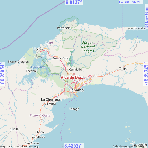
Alcalde Díaz GPS coordinates[2]
9° 7' 12.576" North, 79° 33' 23.076" West
| Map corner | latitude | longitude |
|---|---|---|
| Upper-left | 9.8137°, | -80.25954° |
| Center: | 9.12016°, | -79.55641° |
| Lower-right: | 8.42527°, | -78.85329° |
| Map W x H: | 154.4×154.4 km | = 95.9×95.9mi |
| max Lat: | 9.60898° ⇑12.2% North |
| Alcalde Díaz: | 9.12016° |
| min Lat: | ⇓87.8% South 7.26534° |
| min Long | Alcalde Díaz | max Long |
| -82.91275° | -79.55641° | -77.38965° |
| W 86%⇐ | ⇒14% E |
Elevation
Elevation of Alcalde Díaz is 201 m = 659 ft, and this is 28.9 m = 95 ft above average elevation for this country.
| Max E: |
2103 m = 6900 ft | 25.4% |
| Alcalde Díaz | 201 m 659 ft | |
| Avg. | 172.1 m = 565 ft | |
Min E: |
-1 m = -3 ft | 74.6% |
See also: Panama elevation on elevation.city.
Geographical zone
Alcalde Díaz is located in North Torrid zone (between Equator and Tropic of Cancer). Distance of Equator is 1014.1 km =630.1 mi to South.| Distance of | km | miles | from Alcalde Díaz |
|---|---|---|---|
| North Pole | 8993 | 5588 | to North |
| Arctic Circle | 6387.1 | 3968.8 | to North |
| Tropic Cancer | 1591.9 | 989.2 | to North |
| Equator | 1014.1 | 630.1 | to South |


Nearby cities:
15 places around Alcalde Díaz: (largest is in red/bold)
• Caimitillo
4.3 km =2.7 mi,  24°
24°
• Calzada Larga
5.9 km =3.7 mi,  353°
353°
• Chilibre
7.9 km =4.9 mi,  295°
295°
• Gonzalillo
5.2 km =3.2 mi,  127°
127°
• Juan Díaz
14 km =8.7 mi,  123°
123°
• La Cabima
2.2 km =1.4 mi,  94°
94°
• Las Cumbres
4.6 km =2.9 mi,  137°
137°
• Mocambo Arriba
5.2 km =3.2 mi,  193°
193°
• Paraíso
12.4 km =7.7 mi,  218°
218°
• Parque Lefevre
14 km =8.7 mi,  145°
145°
• Río Abajo
13.1 km =8.1 mi, 151°
• San Antonio
5.9 km =3.7 mi,  9°
9°
• San Miguelito
12.2 km =7.6 mi, 129°
• San Vicente
4.6 km =2.9 mi,  261°
261°
• Villa Unida
10.7 km =6.6 mi,  315°
315°
Sources, notices
• [Note1] Compared only with cities in Panama existing in our database
• [Src1] Map data: © OpenStreetMap contributors (CC-BY-SA)
• [Src2] Other city data from geonames.org with taken over terms of usage.
• [Src3] Geographical zone / Annual Mean Temperature by Robert A. Rohde @ Wikipedia
