El Retiro geodata
El Retiro (Coclé) is a seat of a third-order administrative division; located in Panama in America/Panama (GMT-5) time zone. With population of 450 people, there are 502 cities with bigger population in this country. Compared to other cities in Panama, 51.3% of cities are located further ↓South; 69.5% of cities are located further ←West and 71.2% of cities have lower elevation than El Retiro. Note1


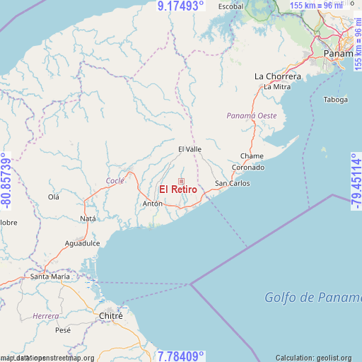
El Retiro GPS coordinates[2]
8° 28' 48.504" North, 80° 9' 15.336" West
| Map corner | latitude | longitude |
|---|---|---|
| Upper-left | 9.17493°, | -80.85739° |
| Center: | 8.48014°, | -80.15426° |
| Lower-right: | 7.78409°, | -79.45114° |
| Map W x H: | 154.6×154.7 km | = 96.1×96.1mi |
| max Lat: | 9.60898° ⇑48.7% North |
| El Retiro: | 8.48014° |
| min Lat: | ⇓51.3% South 7.26534° |
| min Long | El Retiro | max Long |
| -82.91275° | -80.15426° | -77.38965° |
| W 69.5%⇐ | ⇒30.5% E |
Elevation
Elevation of El Retiro is 163 m = 535 ft, and this is 9.1 m = 30 ft below average elevation for this country.
| Max E: |
2103 m = 6900 ft | 28.8% |
| Avg. | 172.1 m = 565 ft | |
| El Retiro | 163 m = 535 ft | |
Min E: |
-1 m = -3 ft | 71.2% |
See also: Panama elevation on elevation.city.
Geographical zone
El Retiro is located in North Torrid zone (between Equator and Tropic of Cancer). Distance of Equator is 942.9 km =585.9 mi to South.| Distance of | km | miles | from El Retiro |
|---|---|---|---|
| North Pole | 9064.2 | 5632.2 | to North |
| Arctic Circle | 6458.3 | 4013 | to North |
| Tropic Cancer | 1663 | 1033.3 | to North |
| Equator | 942.9 | 585.9 | to South |


Nearby cities:
15 places around El Retiro: (largest is in red/bold)
• Buen Retiro
11.2 km =7 mi,  231°
231°
• Caballero
8.5 km =5.3 mi,  325°
325°
• Cabuya
7.6 km =4.7 mi,  348°
348°
• El Chirú
9.7 km =6 mi,  201°
201°
• Entradero
11.5 km =7.1 mi, 329°
• La Ermita
9.8 km =6.1 mi,  105°
105°
• Las Colinas
11 km =6.8 mi,  45°
45°
• Las Matas
7 km =4.3 mi,  100°
100°
• Llano Grande
8.6 km =5.3 mi,  247°
247°
• Los Pollos
9 km =5.6 mi,  182°
182°
• Palo Verde
11.3 km =7 mi, 204°
• Pueblo Nuevo
11.7 km =7.3 mi,  206°
206°
• Río Hato
11.3 km =7 mi,  186°
186°
• San Juan de Dios
11.2 km =7 mi,  314°
314°
• Santa Rita
3.5 km =2.2 mi,  294°
294°
Sources, notices
• [Note1] Compared only with cities in Panama existing in our database
• [Src1] Map data: © OpenStreetMap contributors (CC-BY-SA)
• [Src2] Other city data from geonames.org with taken over terms of usage.
• [Src3] Geographical zone / Annual Mean Temperature by Robert A. Rohde @ Wikipedia
