La Palma geodata
La Palma (Los Santos) is a seat of a third-order administrative division; located in Panama in America/Panama (GMT-5) time zone. With population of 1,144 people, there are 215 cities with bigger population in this country. Compared to other cities in Panama, 94.5% of cities are located further ↑North; 67.5% of cities are located further ←West and 68% of cities have higher elevation than La Palma. Note1


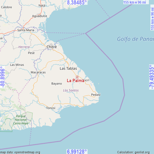
La Palma GPS coordinates[2]
7° 41' 19.104" North, 80° 11' 47.292" West
| Map corner | latitude | longitude |
|---|---|---|
| Upper-left | 8.38485°, | -80.8996° |
| Center: | 7.68864°, | -80.19647° |
| Lower-right: | 6.99128°, | -79.49335° |
| Map W x H: | 155×155 km | = 96.3×96.3mi |
| max Lat: | 9.60898° ⇑94.5% North |
| La Palma: | 7.68864° |
| min Lat: | ⇓5.5% South 7.26534° |
| min Long | La Palma | max Long |
| -82.91275° | -80.19647° | -77.38965° |
| W 67.5%⇐ | ⇒32.5% E |
Elevation
Elevation of La Palma is 38 m = 125 ft, and this is 134.1 m = 440 ft below average elevation for this country.
| Max E: |
2103 m = 6900 ft | 68% |
| Avg. | 172.1 m = 565 ft | |
| La Palma | 38 m = 125 ft | |
Min E: |
-1 m = -3 ft | 32% |
See also: Panama elevation on elevation.city.
Geographical zone
La Palma is located in North Torrid zone (between Equator and Tropic of Cancer). Distance of Equator is 854.9 km =531.2 mi to South.| Distance of | km | miles | from La Palma |
|---|---|---|---|
| North Pole | 9152.2 | 5686.9 | to North |
| Arctic Circle | 6546.3 | 4067.7 | to North |
| Tropic Cancer | 1751 | 1088 | to North |
| Equator | 854.9 | 531.2 | to South |


Nearby cities:
15 places around La Palma: (largest is in red/bold)
• Bajo Corral
11.7 km =7.3 mi,  216°
216°
• Bella Vista
7.9 km =4.9 mi,  329°
329°
• El Carate
12 km =7.5 mi,  293°
293°
• El Cañafístulo
8.9 km =5.5 mi,  207°
207°
• El Cocal
10.6 km =6.6 mi,  300°
300°
• El Manantial
11.8 km =7.3 mi, 331°
• La Laja
7.8 km =4.8 mi,  307°
307°
• Las Tablas
12.1 km =7.5 mi, 314°
• Paraíso
3.9 km =2.4 mi,  95°
95°
• Paritilla
7.2 km =4.5 mi,  158°
158°
• Peña Blanca
10.2 km =6.3 mi, 289°
• Pocrí
9 km =5.6 mi,  112°
112°
• San José
5.5 km =3.4 mi,  252°
252°
• Santo Domingo
8.1 km =5 mi,  322°
322°
• Sesteadero
8 km =5 mi, 314°
Sources, notices
• [Note1] Compared only with cities in Panama existing in our database
• [Src1] Map data: © OpenStreetMap contributors (CC-BY-SA)
• [Src2] Other city data from geonames.org with taken over terms of usage.
• [Src3] Geographical zone / Annual Mean Temperature by Robert A. Rohde @ Wikipedia
