La Enea geodata
La Enea (Los Santos) is a seat of a third-order administrative division; located in Panama in America/Panama (GMT-5) time zone. With population of 1,105 people, there are 224 cities with bigger population in this country. Compared to other cities in Panama, 88.5% of cities are located further ↑North; 63.5% of cities are located further ←West and 70.7% of cities have higher elevation than La Enea. Note1


La Enea GPS coordinates[2]
7° 49' 59.988" North, 80° 16' 27.012" West
| Map corner | latitude | longitude |
|---|---|---|
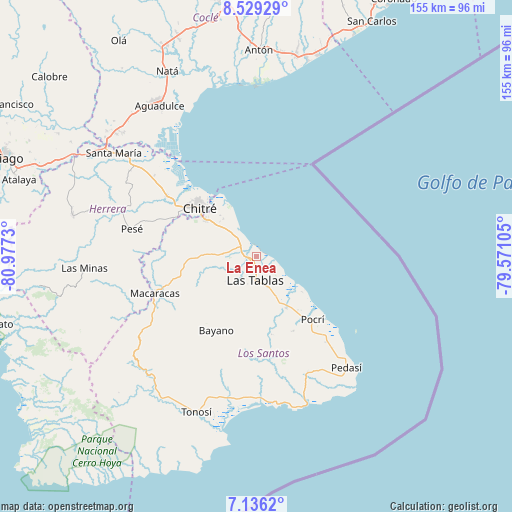
| Upper-left | 8.52929°, | -80.9773° |
| Center: | 7.83333°, | -80.27417° |
| Lower-right: | 7.1362°, | -79.57105° |
| Map W x H: | 154.9×154.9 km | = 96.3×96.3mi |
| max Lat: | 9.60898° ⇑88.5% North |
| La Enea: | 7.83333° |
| min Lat: | ⇓11.5% South 7.26534° |
| min Long | La Enea | max Long |
| -82.91275° | -80.27417° | -77.38965° |
| W 63.5%⇐ | ⇒36.5% E |
Elevation
Elevation of La Enea is 35 m = 115 ft, and this is 137.1 m = 450 ft below average elevation for this country.
| Max E: |
2103 m = 6900 ft | 70.7% |
| Avg. | 172.1 m = 565 ft | |
| La Enea | 35 m = 115 ft | |
Min E: |
-1 m = -3 ft | 29.3% |
See also: Panama elevation on elevation.city.
Geographical zone
La Enea is located in North Torrid zone (between Equator and Tropic of Cancer). Distance of Equator is 871 km =541.2 mi to South.| Distance of | km | miles | from La Enea |
|---|---|---|---|
| North Pole | 9136.1 | 5676.9 | to North |
| Arctic Circle | 6530.2 | 4057.7 | to North |
| Tropic Cancer | 1734.9 | 1078 | to North |
| Equator | 871 | 541.2 | to South |


Nearby cities:
15 places around La Enea: (largest is in red/bold)
• Bella Vista
10.3 km =6.4 mi,  154°
154°
• El Cocal
10.7 km =6.6 mi,  183°
183°
• El Espinal
6.2 km =3.9 mi,  306°
306°
• El Manantial
6.4 km =4 mi, 152°
• Guararé
2.2 km =1.4 mi,  207°
207°
• Guararé Arriba
10.1 km =6.3 mi,  248°
248°
• La Pasera
5.1 km =3.2 mi,  219°
219°
• La Tiza
9.4 km =5.8 mi,  192°
192°
• Las Palmitas
7.9 km =4.9 mi,  195°
195°
• Las Tablas
7.6 km =4.7 mi, 180°
• Las Tablas Abajo
4.8 km =3 mi, 149°
• Los Ángeles
10.8 km =6.7 mi,  301°
301°
• Perales
8.6 km =5.3 mi, 220°
• Sabana Grande
10 km =6.2 mi,  271°
271°
• Santo Domingo
10.3 km =6.4 mi,  159°
159°
Sources, notices
• [Note1] Compared only with cities in Panama existing in our database
• [Src1] Map data: © OpenStreetMap contributors (CC-BY-SA)
• [Src2] Other city data from geonames.org with taken over terms of usage.
• [Src3] Geographical zone / Annual Mean Temperature by Robert A. Rohde @ Wikipedia
