Guararé geodata
Guararé (Los Santos) is a seat of a second-order administrative division; located in Panama in America/Panama (GMT-5) time zone. With population of 3,243 people, there are 90 cities with bigger population in this country. Compared to other cities in Panama, 89% of cities are located further ↑North; 62.8% of cities are located further ←West and 75.7% of cities have higher elevation than Guararé. Note1


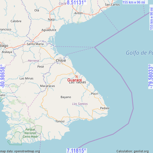
Guararé GPS coordinates[2]
7° 48' 55.116" North, 80° 17' 0.42" West
| Map corner | latitude | longitude |
|---|---|---|
| Upper-left | 8.51131°, | -80.98658° |
| Center: | 7.81531°, | -80.28345° |
| Lower-right: | 7.11815°, | -79.58033° |
| Map W x H: | 154.9×154.9 km | = 96.3×96.3mi |
| max Lat: | 9.60898° ⇑89% North |
| Guararé: | 7.81531° |
| min Lat: | ⇓11% South 7.26534° |
| min Long | Guararé | max Long |
| -82.91275° | -80.28345° | -77.38965° |
| W 62.8%⇐ | ⇒37.2% E |
Elevation
Elevation of Guararé is 29 m = 95 ft, and this is 143.1 m = 469 ft below average elevation for this country.
| Max E: |
2103 m = 6900 ft | 75.7% |
| Avg. | 172.1 m = 565 ft | |
| Guararé | 29 m = 95 ft | |
Min E: |
-1 m = -3 ft | 24.3% |
See also: Panama elevation on elevation.city.
Geographical zone
Guararé is located in North Torrid zone (between Equator and Tropic of Cancer). Distance of Equator is 869 km =540 mi to South.| Distance of | km | miles | from Guararé |
|---|---|---|---|
| North Pole | 9138.1 | 5678.2 | to North |
| Arctic Circle | 6532.2 | 4058.9 | to North |
| Tropic Cancer | 1736.9 | 1079.3 | to North |
| Equator | 869 | 540 | to South |


Nearby cities:
15 places around Guararé: (largest is in red/bold)
• Bella Vista
9.1 km =5.7 mi,  142°
142°
• El Cocal
8.7 km =5.4 mi,  177°
177°
• El Espinal
6.9 km =4.3 mi,  325°
325°
• El Manantial
5.4 km =3.4 mi,  132°
132°
• Guararé Arriba
8.6 km =5.3 mi,  258°
258°
• La Enea
2.2 km =1.4 mi,  27°
27°
• La Pasera
3 km =1.9 mi,  228°
228°
• La Tiza
7.2 km =4.5 mi,  187°
187°
• Las Palmitas
5.7 km =3.5 mi, 191°
• Las Tablas
5.7 km =3.5 mi,  170°
170°
• Las Tablas Abajo
4 km =2.5 mi,  121°
121°
• Perales
6.4 km =4 mi, 225°
• Sabana Grande
9.2 km =5.7 mi,  284°
284°
• Santo Domingo
9 km =5.6 mi,  149°
149°
• Sesteadero
9.3 km =5.8 mi,  155°
155°
Sources, notices
• [Note1] Compared only with cities in Panama existing in our database
• [Src1] Map data: © OpenStreetMap contributors (CC-BY-SA)
• [Src2] Other city data from geonames.org with taken over terms of usage.
• [Src3] Geographical zone / Annual Mean Temperature by Robert A. Rohde @ Wikipedia
