El Espinal geodata
El Espinal (Los Santos) is a seat of a third-order administrative division; located in Panama in America/Panama (GMT-5) time zone. In our database, there are 694 cities with bigger population. Compared to other cities in Panama, 87.7% of cities are located further ↑North; 61.7% of cities are located further ←West and 77% of cities have higher elevation than El Espinal. Note1


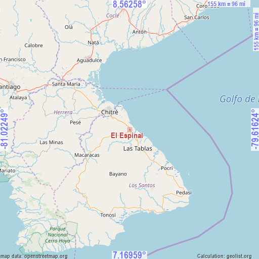
El Espinal GPS coordinates[2]
7° 52' 0.012" North, 80° 19' 9.696" West
| Map corner | latitude | longitude |
|---|---|---|
| Upper-left | 8.56258°, | -81.02249° |
| Center: | 7.86667°, | -80.31936° |
| Lower-right: | 7.16959°, | -79.61624° |
| Map W x H: | 154.9×154.9 km | = 96.3×96.3mi |
| max Lat: | 9.60898° ⇑87.7% North |
| El Espinal: | 7.86667° |
| min Lat: | ⇓12.3% South 7.26534° |
| min Long | El Espinal | max Long |
| -82.91275° | -80.31936° | -77.38965° |
| W 61.7%⇐ | ⇒38.3% E |
Elevation
Elevation of El Espinal is 28 m = 92 ft, and this is 144.1 m = 473 ft below average elevation for this country.
| Max E: |
2103 m = 6900 ft | 77% |
| Avg. | 172.1 m = 565 ft | |
| El Espinal | 28 m = 92 ft | |
Min E: |
-1 m = -3 ft | 23% |
See also: Panama elevation on elevation.city.
Geographical zone
El Espinal is located in North Torrid zone (between Equator and Tropic of Cancer). Distance of Equator is 874.7 km =543.5 mi to South.| Distance of | km | miles | from El Espinal |
|---|---|---|---|
| North Pole | 9132.4 | 5674.6 | to North |
| Arctic Circle | 6526.5 | 4055.4 | to North |
| Tropic Cancer | 1731.2 | 1075.7 | to North |
| Equator | 874.7 | 543.5 | to South |


Nearby cities:
15 places around El Espinal: (largest is in red/bold)
• Agua Buena
9 km =5.6 mi,  246°
246°
• El Ejido
9.3 km =5.8 mi,  306°
306°
• El Hato
10.7 km =6.6 mi,  220°
220°
• Guararé
6.9 km =4.3 mi,  145°
145°
• Guararé Arriba
8.6 km =5.3 mi,  211°
211°
• La Enea
6.2 km =3.9 mi,  126°
126°
• La Espigadilla
8.1 km =5 mi,  283°
283°
• La Pasera
7.9 km =4.9 mi,  167°
167°
• Las Palmitas
11.6 km =7.2 mi, 165°
• Las Tablas Abajo
10.8 km =6.7 mi,  136°
136°
• Los Ángeles
4.7 km =2.9 mi,  294°
294°
• Perales
10.3 km =6.4 mi,  183°
183°
• Sabana Grande
6.1 km =3.8 mi,  235°
235°
• Santa Ana Arriba
8.8 km =5.5 mi,  326°
326°
• Tres Quebradas
10.1 km =6.3 mi, 253°
Sources, notices
• [Note1] Compared only with cities in Panama existing in our database
• [Src1] Map data: © OpenStreetMap contributors (CC-BY-SA)
• [Src2] Other city data from geonames.org with taken over terms of usage.
• [Src3] Geographical zone / Annual Mean Temperature by Robert A. Rohde @ Wikipedia
