Guayabal geodata
Guayabal (Chiriquí) is a seat of a third-order administrative division; located in Panama in America/Panama (GMT-5) time zone. With population of 220 people, there are 594 cities with bigger population in this country. Compared to other cities in Panama, 65.4% of cities are located further ↓South; 91.2% of cities are located further →East and 94% of cities have lower elevation than Guayabal. Note1


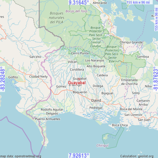
Guayabal GPS coordinates[2]
8° 37' 18.948" North, 82° 34' 45.66" West
| Map corner | latitude | longitude |
|---|---|---|
| Upper-left | 9.31645°, | -83.28248° |
| Center: | 8.62193°, | -82.57935° |
| Lower-right: | 7.92613°, | -81.87623° |
| Map W x H: | 154.6×154.6 km | = 96.1×96.1mi |
| max Lat: | 9.60898° ⇑34.6% North |
| Guayabal: | 8.62193° |
| min Lat: | ⇓65.4% South 7.26534° |
| min Long | Guayabal | max Long |
| -82.91275° | -82.57935° | -77.38965° |
| W 8.8%⇐ | ⇒91.2% E |
Elevation
Elevation of Guayabal is 619 m = 2031 ft, and this is 446.9 m = 1466 ft above average elevation for this country.
| Max E: |
2103 m = 6900 ft | 6% |
| Guayabal | 619 m 2031 ft | |
| Avg. | 172.1 m = 565 ft | |
Min E: |
-1 m = -3 ft | 94% |
See also: Panama elevation on elevation.city.
Geographical zone
Guayabal is located in North Torrid zone (between Equator and Tropic of Cancer). Distance of Equator is 958.7 km =595.7 mi to South.| Distance of | km | miles | from Guayabal |
|---|---|---|---|
| North Pole | 9048.4 | 5622.4 | to North |
| Arctic Circle | 6442.5 | 4003.2 | to North |
| Tropic Cancer | 1647.3 | 1023.6 | to North |
| Equator | 958.7 | 595.7 | to South |


Nearby cities:
15 places around Guayabal: (largest is in red/bold)
• Bongo Arriba
6 km =3.7 mi,  232°
232°
• Bugabita Arriba
12.8 km =8 mi,  209°
209°
• Cordillera
9.8 km =6.1 mi,  344°
344°
• El Banco
10.7 km =6.6 mi,  43°
43°
• Guabal
7 km =4.3 mi,  138°
138°
• La Concepción
12.9 km =8 mi,  199°
199°
• La Meseta
7.8 km =4.8 mi,  192°
192°
• Paraíso
4.1 km =2.5 mi,  349°
349°
• Potrerillos Abajo
10.5 km =6.5 mi,  79°
79°
• Potrerillos Arriba
12 km =7.5 mi,  53°
53°
• Rovira Arriba
8.9 km =5.5 mi, 78°
• San Miguel del Yuco
9.8 km =6.1 mi, 211°
• San Vicente
7.2 km =4.5 mi,  240°
240°
• Santa Rosa
11.9 km =7.4 mi,  257°
257°
• Sortova
11.6 km =7.2 mi,  223°
223°
Sources, notices
• [Note1] Compared only with cities in Panama existing in our database
• [Src1] Map data: © OpenStreetMap contributors (CC-BY-SA)
• [Src2] Other city data from geonames.org with taken over terms of usage.
• [Src3] Geographical zone / Annual Mean Temperature by Robert A. Rohde @ Wikipedia
