El Banco geodata
El Banco (Chiriquí) is a populated place; located in Panama in America/Panama (GMT-5) time zone. With population of 542 people, there are 448 cities with bigger population in this country. Compared to other cities in Panama, 69.9% of cities are located further ↓South; 89.2% of cities are located further →East and 97.4% of cities have lower elevation than El Banco. Note1


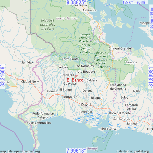
El Banco GPS coordinates[2]
8° 41' 30.696" North, 82° 30' 46.548" West
| Map corner | latitude | longitude |
|---|---|---|
| Upper-left | 9.38625°, | -83.21606° |
| Center: | 8.69186°, | -82.51293° |
| Lower-right: | 7.99618°, | -81.80981° |
| Map W x H: | 154.6×154.6 km | = 96.1×96.1mi |
| max Lat: | 9.60898° ⇑30.1% North |
| El Banco: | 8.69186° |
| min Lat: | ⇓69.9% South 7.26534° |
| min Long | El Banco | max Long |
| -82.91275° | -82.51293° | -77.38965° |
| W 10.8%⇐ | ⇒89.2% E |
Elevation
Elevation of El Banco is 1022 m = 3353 ft, and this is 849.9 m = 2788 ft above average elevation for this country.
| Max E: |
2103 m = 6900 ft | 2.6% |
| El Banco | 1022 m 3353 ft | |
| Avg. | 172.1 m = 565 ft | |
Min E: |
-1 m = -3 ft | 97.4% |
See also: Panama elevation on elevation.city.
Geographical zone
El Banco is located in North Torrid zone (between Equator and Tropic of Cancer). Distance of Equator is 966.4 km =600.5 mi to South.| Distance of | km | miles | from El Banco |
|---|---|---|---|
| North Pole | 9040.6 | 5617.6 | to North |
| Arctic Circle | 6434.7 | 3998.3 | to North |
| Tropic Cancer | 1639.5 | 1018.7 | to North |
| Equator | 966.4 | 600.5 | to South |


Nearby cities:
15 places around El Banco: (largest is in red/bold)
• Alto Boquete
10.1 km =6.3 mi,  61°
61°
• Alto Lino
14.7 km =9.1 mi,  35°
35°
• Alto Quiel
13.3 km =8.3 mi,  18°
18°
• Bajo Boquete
12.4 km =7.7 mi,  45°
45°
• Boquete
12.6 km =7.8 mi, 38°
• Cordillera
10.1 km =6.3 mi,  279°
279°
• Guabal
13.3 km =8.3 mi,  191°
191°
• Guayabal
10.7 km =6.6 mi,  223°
223°
• Los Naranjos
13.3 km =8.3 mi,  33°
33°
• Palmira
7.6 km =4.7 mi, 51°
• Palmira Centro
8.5 km =5.3 mi, 51°
• Paraíso
8.9 km =5.5 mi,  245°
245°
• Potrerillos Abajo
6.5 km =4 mi,  152°
152°
• Potrerillos Arriba
2.5 km =1.6 mi,  106°
106°
• Rovira Arriba
6.1 km =3.8 mi,  166°
166°
Sources, notices
• [Note1] Compared only with cities in Panama existing in our database
• [Src1] Map data: © OpenStreetMap contributors (CC-BY-SA)
• [Src2] Other city data from geonames.org with taken over terms of usage.
• [Src3] Geographical zone / Annual Mean Temperature by Robert A. Rohde @ Wikipedia
