Paraíso geodata
Paraíso (Chiriquí) is a seat of a third-order administrative division; located in Panama in America/Panama (GMT-5) time zone. With population of 242 people, there are 582 cities with bigger population in this country. Compared to other cities in Panama, 68% of cities are located further ↓South; 91.3% of cities are located further →East and 96% of cities have lower elevation than Paraíso. Note1


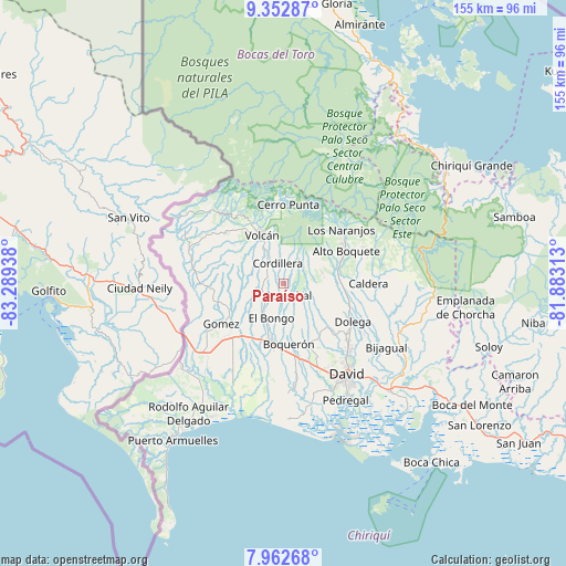
Paraíso GPS coordinates[2]
8° 39' 30.312" North, 82° 35' 10.5" West
| Map corner | latitude | longitude |
|---|---|---|
| Upper-left | 9.35287°, | -83.28938° |
| Center: | 8.65842°, | -82.58625° |
| Lower-right: | 7.96268°, | -81.88313° |
| Map W x H: | 154.6×154.6 km | = 96.1×96.1mi |
| max Lat: | 9.60898° ⇑32% North |
| Paraíso: | 8.65842° |
| min Lat: | ⇓68% South 7.26534° |
| min Long | Paraíso | max Long |
| -82.91275° | -82.58625° | -77.38965° |
| W 8.7%⇐ | ⇒91.3% E |
Elevation
Elevation of Paraíso is 806 m = 2644 ft, and this is 633.9 m = 2080 ft above average elevation for this country.
| Max E: |
2103 m = 6900 ft | 4% |
| Paraíso | 806 m 2644 ft | |
| Avg. | 172.1 m = 565 ft | |
Min E: |
-1 m = -3 ft | 96% |
See also: Panama elevation on elevation.city.
Geographical zone
Paraíso is located in North Torrid zone (between Equator and Tropic of Cancer). Distance of Equator is 962.7 km =598.2 mi to South.| Distance of | km | miles | from Paraíso |
|---|---|---|---|
| North Pole | 9044.3 | 5619.9 | to North |
| Arctic Circle | 6438.4 | 4000.6 | to North |
| Tropic Cancer | 1643.2 | 1021 | to North |
| Equator | 962.7 | 598.2 | to South |


Nearby cities:
15 places around Paraíso: (largest is in red/bold)
• Bongo Arriba
8.7 km =5.4 mi,  207°
207°
• Cordillera
5.7 km =3.5 mi,  340°
340°
• El Banco
8.9 km =5.5 mi,  65°
65°
• El Santo
14.9 km =9.3 mi,  223°
223°
• Guabal
10.8 km =6.7 mi,  149°
149°
• Guayabal
4.1 km =2.5 mi,  169°
169°
• La Meseta
11.7 km =7.3 mi,  184°
184°
• Potrerillos Abajo
11.3 km =7 mi,  100°
100°
• Potrerillos Arriba
10.9 km =6.8 mi, 73°
• Rovira Arriba
9.8 km =6.1 mi, 103°
• San Miguel del Yuco
13.2 km =8.2 mi,  199°
199°
• San Vicente
9.4 km =5.8 mi, 216°
• Santa Rosa
12.7 km =7.9 mi,  238°
238°
• Sortova
14.4 km =8.9 mi, 210°
• Volcán
14 km =8.7 mi, 335°
Sources, notices
• [Note1] Compared only with cities in Panama existing in our database
• [Src1] Map data: © OpenStreetMap contributors (CC-BY-SA)
• [Src2] Other city data from geonames.org with taken over terms of usage.
• [Src3] Geographical zone / Annual Mean Temperature by Robert A. Rohde @ Wikipedia
