Guabal geodata
Guabal (Chiriquí) is a seat of a third-order administrative division; located in Panama in America/Panama (GMT-5) time zone. With population of 147 people, there are 632 cities with bigger population in this country. Compared to other cities in Panama, 61.7% of cities are located further ↓South; 90.1% of cities are located further →East and 90.3% of cities have lower elevation than Guabal. Note1


Guabal GPS coordinates[2]
8° 34' 28.776" North, 82° 32' 14.28" West
| Map corner | latitude | longitude |
|---|---|---|
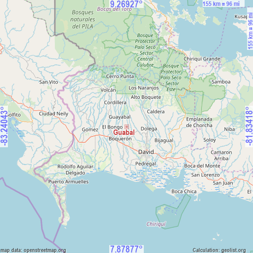
| Upper-left | 9.26927°, | -83.24043° |
| Center: | 8.57466°, | -82.5373° |
| Lower-right: | 7.87877°, | -81.83418° |
| Map W x H: | 154.6×154.6 km | = 96.1×96.1mi |
| max Lat: | 9.60898° ⇑38.3% North |
| Guabal: | 8.57466° |
| min Lat: | ⇓61.7% South 7.26534° |
| min Long | Guabal | max Long |
| -82.91275° | -82.5373° | -77.38965° |
| W 9.9%⇐ | ⇒90.1% E |
Elevation
Elevation of Guabal is 444 m = 1457 ft, and this is 271.9 m = 892 ft above average elevation for this country.
| Max E: |
2103 m = 6900 ft | 9.7% |
| Guabal | 444 m 1457 ft | |
| Avg. | 172.1 m = 565 ft | |
Min E: |
-1 m = -3 ft | 90.3% |
See also: Panama elevation on elevation.city.
Geographical zone
Guabal is located in North Torrid zone (between Equator and Tropic of Cancer). Distance of Equator is 953.4 km =592.4 mi to South.| Distance of | km | miles | from Guabal |
|---|---|---|---|
| North Pole | 9053.6 | 5625.6 | to North |
| Arctic Circle | 6447.8 | 4006.5 | to North |
| Tropic Cancer | 1652.5 | 1026.8 | to North |
| Equator | 953.4 | 592.4 | to South |


Nearby cities:
15 places around Guabal: (largest is in red/bold)
• Bongo Arriba
9.5 km =5.9 mi,  279°
279°
• Boquerón
8.5 km =5.3 mi,  205°
205°
• El Flor
10.8 km =6.7 mi,  93°
93°
• Guaca Arriba
6.4 km =4 mi,  130°
130°
• Guayabal
7 km =4.3 mi,  318°
318°
• La Meseta
6.8 km =4.2 mi,  249°
249°
• Paraíso
10.8 km =6.7 mi,  329°
329°
• Potrerillos Abajo
9.2 km =5.7 mi,  38°
38°
• Pueblo Nuevo
6 km =3.7 mi,  143°
143°
• Rovira Arriba
8.2 km =5.1 mi,  30°
30°
• San Carlos
7.2 km =4.5 mi,  154°
154°
• San Juan del Tejal
10.9 km =6.8 mi, 152°
• San Miguel del Yuco
10.2 km =6.3 mi, 251°
• San Pablo Viejo Arriba
11.1 km =6.9 mi,  161°
161°
• Tinajas
8.9 km =5.5 mi,  105°
105°
Sources, notices
• [Note1] Compared only with cities in Panama existing in our database
• [Src1] Map data: © OpenStreetMap contributors (CC-BY-SA)
• [Src2] Other city data from geonames.org with taken over terms of usage.
• [Src3] Geographical zone / Annual Mean Temperature by Robert A. Rohde @ Wikipedia
