Potrerillos Arriba geodata
Potrerillos Arriba (Chiriquí) is a seat of a third-order administrative division; located in Panama in America/Panama (GMT-5) time zone. With population of 1,074 people, there are 233 cities with bigger population in this country. Compared to other cities in Panama, 69.6% of cities are located further ↓South; 87.9% of cities are located further →East and 96.7% of cities have lower elevation than Potrerillos Arriba. Note1


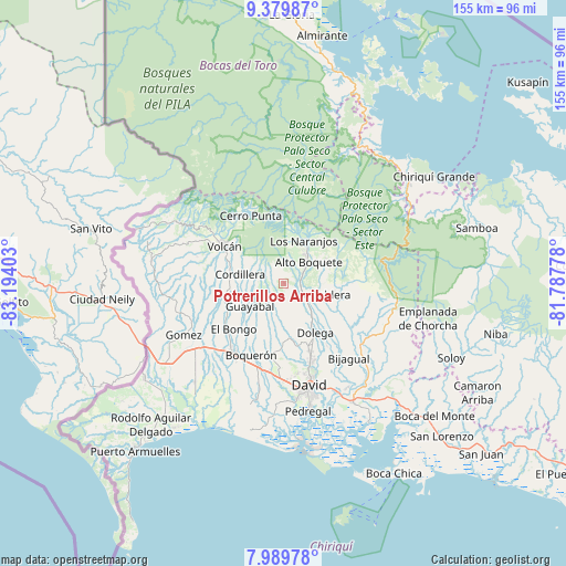
Potrerillos Arriba GPS coordinates[2]
8° 41' 7.692" North, 82° 29' 27.24" West
| Map corner | latitude | longitude |
|---|---|---|
| Upper-left | 9.37987°, | -83.19403° |
| Center: | 8.68547°, | -82.4909° |
| Lower-right: | 7.98978°, | -81.78778° |
| Map W x H: | 154.6×154.6 km | = 96.1×96.1mi |
| max Lat: | 9.60898° ⇑30.4% North |
| Potrerillos Arriba: | 8.68547° |
| min Lat: | ⇓69.6% South 7.26534° |
| min Long | Potrerillos Arr | max Long |
| -82.91275° | -82.4909° | -77.38965° |
| W 12.1%⇐ | ⇒87.9% E |
Elevation
Elevation of Potrerillos Arriba is 904 m = 2966 ft, and this is 731.9 m = 2401 ft above average elevation for this country.
| Max E: |
2103 m = 6900 ft | 3.3% |
| Potrerillos Arriba | 904 m 2966 ft | |
| Avg. | 172.1 m = 565 ft | |
Min E: |
-1 m = -3 ft | 96.7% |
See also: Panama elevation on elevation.city.
Geographical zone
Potrerillos Arriba is located in North Torrid zone (between Equator and Tropic of Cancer). Distance of Equator is 965.7 km =600.1 mi to South.| Distance of | km | miles | from Potrerillos Arriba |
|---|---|---|---|
| North Pole | 9041.3 | 5618 | to North |
| Arctic Circle | 6435.4 | 3998.8 | to North |
| Tropic Cancer | 1640.2 | 1019.2 | to North |
| Equator | 965.7 | 600.1 | to South |


Nearby cities:
15 places around Potrerillos Arriba: (largest is in red/bold)
• Alto Boquete
8.5 km =5.3 mi,  49°
49°
• Alto Quiel
13.4 km =8.3 mi,  7°
7°
• Bajo Boquete
11.4 km =7.1 mi,  33°
33°
• Boquete
11.9 km =7.4 mi, 27°
• Caldera
12.8 km =8 mi,  108°
108°
• Cordillera
12.6 km =7.8 mi,  280°
280°
• El Banco
2.5 km =1.6 mi,  286°
286°
• Guabal
13.3 km =8.3 mi,  202°
202°
• Guayabal
12 km =7.5 mi,  233°
233°
• Los Naranjos
12.8 km =8 mi,  22°
22°
• Palmira
6.4 km =4 mi, 33°
• Palmira Centro
7.4 km =4.6 mi,  35°
35°
• Paraíso
10.9 km =6.8 mi,  253°
253°
• Potrerillos Abajo
5.1 km =3.2 mi,  173°
173°
• Rovira Arriba
5.3 km =3.3 mi,  190°
190°
Sources, notices
• [Note1] Compared only with cities in Panama existing in our database
• [Src1] Map data: © OpenStreetMap contributors (CC-BY-SA)
• [Src2] Other city data from geonames.org with taken over terms of usage.
• [Src3] Geographical zone / Annual Mean Temperature by Robert A. Rohde @ Wikipedia
