Las Minas geodata
Las Minas (Herrera) is a seat of a second-order administrative division; located in Panama in America/Panama (GMT-5) time zone. With population of 889 people, there are 285 cities with bigger population in this country. Compared to other cities in Panama, 90.2% of cities are located further ↑North; 55.5% of cities are located further →East and 84.8% of cities have lower elevation than Las Minas. Note1


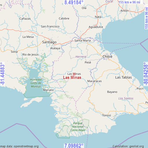
Las Minas GPS coordinates[2]
7° 47' 44.916" North, 80° 44' 44.52" West
| Map corner | latitude | longitude |
|---|---|---|
| Upper-left | 8.49184°, | -81.44883° |
| Center: | 7.79581°, | -80.7457° |
| Lower-right: | 7.09862°, | -80.04258° |
| Map W x H: | 154.9×154.9 km | = 96.3×96.3mi |
| max Lat: | 9.60898° ⇑90.2% North |
| Las Minas: | 7.79581° |
| min Lat: | ⇓9.8% South 7.26534° |
| min Long | Las Minas | max Long |
| -82.91275° | -80.7457° | -77.38965° |
| W 44.5%⇐ | ⇒55.5% E |
Elevation
Elevation of Las Minas is 337 m = 1106 ft, and this is 164.9 m = 541 ft above average elevation for this country.
| Max E: |
2103 m = 6900 ft | 15.2% |
| Las Minas | 337 m 1106 ft | |
| Avg. | 172.1 m = 565 ft | |
Min E: |
-1 m = -3 ft | 84.8% |
See also: Panama elevation on elevation.city.
Geographical zone
Las Minas is located in North Torrid zone (between Equator and Tropic of Cancer). Distance of Equator is 866.8 km =538.6 mi to South.| Distance of | km | miles | from Las Minas |
|---|---|---|---|
| North Pole | 9140.2 | 5679.5 | to North |
| Arctic Circle | 6534.4 | 4060.3 | to North |
| Tropic Cancer | 1739.1 | 1080.6 | to North |
| Equator | 866.8 | 538.6 | to South |


Nearby cities:
15 places around Las Minas: (largest is in red/bold)
• Cerro Largo
10.4 km =6.5 mi,  294°
294°
• Chumical
5.9 km =3.7 mi,  21°
21°
• El Capurí
13.7 km =8.5 mi,  124°
124°
• El Cedro
15.5 km =9.6 mi,  142°
142°
• El Toro
14.5 km =9 mi,  249°
249°
• La Trinidad
14 km =8.7 mi, 19°
• Las Guabas
14.3 km =8.9 mi,  331°
331°
• Leones Arriba
11.4 km =7.1 mi, 253°
• Los Cerritos
14.9 km =9.3 mi,  89°
89°
• Los Cerros de Paja
11.8 km =7.3 mi, 137°
• Los Pozos
11.2 km =7 mi,  97°
97°
• Ocú
16.5 km =10.3 mi,  347°
347°
• Quebrada del Rosario
9.3 km =5.8 mi,  177°
177°
• Rincón Hondo
16.5 km =10.3 mi,  70°
70°
• Sabana Grande
15.1 km =9.4 mi,  51°
51°
Sources, notices
• [Note1] Compared only with cities in Panama existing in our database
• [Src1] Map data: © OpenStreetMap contributors (CC-BY-SA)
• [Src2] Other city data from geonames.org with taken over terms of usage.
• [Src3] Geographical zone / Annual Mean Temperature by Robert A. Rohde @ Wikipedia
