Rincón Hondo geodata
Rincón Hondo (Herrera) is a seat of a third-order administrative division; located in Panama in America/Panama (GMT-5) time zone. With population of 359 people, there are 535 cities with bigger population in this country. Compared to other cities in Panama, 87.9% of cities are located further ↑North; 50.8% of cities are located further →East and 58.1% of cities have higher elevation than Rincón Hondo. Note1


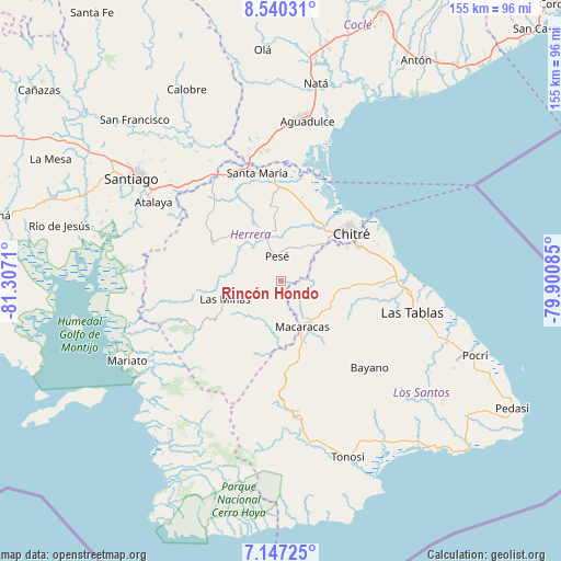
Rincón Hondo GPS coordinates[2]
7° 50' 39.696" North, 80° 36' 14.292" West
| Map corner | latitude | longitude |
|---|---|---|
| Upper-left | 8.54031°, | -81.3071° |
| Center: | 7.84436°, | -80.60397° |
| Lower-right: | 7.14725°, | -79.90085° |
| Map W x H: | 154.9×154.9 km | = 96.3×96.3mi |
| max Lat: | 9.60898° ⇑87.9% North |
| Rincón Hondo: | 7.84436° |
| min Lat: | ⇓12.1% South 7.26534° |
| min Long | Rincón Hondo | max Long |
| -82.91275° | -80.60397° | -77.38965° |
| W 49.2%⇐ | ⇒50.8% E |
Elevation
Elevation of Rincón Hondo is 58 m = 190 ft, and this is 114.1 m = 374 ft below average elevation for this country.
| Max E: |
2103 m = 6900 ft | 58.1% |
| Avg. | 172.1 m = 565 ft | |
| Rincón Hondo | 58 m = 190 ft | |
Min E: |
-1 m = -3 ft | 41.9% |
See also: Panama elevation on elevation.city.
Geographical zone
Rincón Hondo is located in North Torrid zone (between Equator and Tropic of Cancer). Distance of Equator is 872.2 km =542 mi to South.| Distance of | km | miles | from Rincón Hondo |
|---|---|---|---|
| North Pole | 9134.9 | 5676.2 | to North |
| Arctic Circle | 6529 | 4056.9 | to North |
| Tropic Cancer | 1733.7 | 1077.3 | to North |
| Equator | 872.2 | 542 | to South |


Nearby cities:
15 places around Rincón Hondo: (largest is in red/bold)
• Cedro Arriba
10.7 km =6.6 mi,  131°
131°
• Chupá
5.9 km =3.7 mi,  146°
146°
• El Guásimo
9.2 km =5.7 mi,  117°
117°
• El Pedregoso
10.9 km =6.8 mi,  339°
339°
• El Pájaro
11.6 km =7.2 mi,  18°
18°
• La Arena
10.5 km =6.5 mi,  173°
173°
• La Colorada
5.8 km =3.6 mi,  113°
113°
• Las Cabras
7 km =4.3 mi,  60°
60°
• Las Guabas
11.8 km =7.3 mi, 106°
• Llano de La Cruz
12.7 km =7.9 mi, 340°
• Los Cerritos
5.3 km =3.3 mi,  188°
188°
• Los Hatillos
12 km =7.5 mi,  37°
37°
• Los Pozos
8.2 km =5.1 mi,  213°
213°
• Pesé
7.2 km =4.5 mi,  350°
350°
• Sabana Grande
5.5 km =3.4 mi,  316°
316°
Sources, notices
• [Note1] Compared only with cities in Panama existing in our database
• [Src1] Map data: © OpenStreetMap contributors (CC-BY-SA)
• [Src2] Other city data from geonames.org with taken over terms of usage.
• [Src3] Geographical zone / Annual Mean Temperature by Robert A. Rohde @ Wikipedia
