Boró geodata
Boró (Veraguas) is a seat of a third-order administrative division; located in Panama in America/Panama (GMT-5) time zone. With population of 326 people, there are 549 cities with bigger population in this country. Compared to other cities in Panama, 73.3% of cities are located further ↑North; 66.8% of cities are located further →East and 73.9% of cities have lower elevation than Boró. Note1


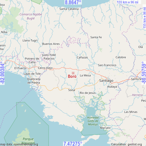
Boró GPS coordinates[2]
8° 10' 9.588" North, 81° 18' 2.556" West
| Map corner | latitude | longitude |
|---|---|---|
| Upper-left | 8.8647°, | -82.00384° |
| Center: | 8.16933°, | -81.30071° |
| Lower-right: | 7.47275°, | -80.59759° |
| Map W x H: | 154.8×154.8 km | = 96.2×96.2mi |
| max Lat: | 9.60898° ⇑73.3% North |
| Boró: | 8.16933° |
| min Lat: | ⇓26.7% South 7.26534° |
| min Long | Boró | max Long |
| -82.91275° | -81.30071° | -77.38965° |
| W 33.2%⇐ | ⇒66.8% E |
Elevation
Elevation of Boró is 189 m = 620 ft, and this is 16.9 m = 55 ft above average elevation for this country.
| Max E: |
2103 m = 6900 ft | 26.1% |
| Boró | 189 m 620 ft | |
| Avg. | 172.1 m = 565 ft | |
Min E: |
-1 m = -3 ft | 73.9% |
See also: Panama elevation on elevation.city.
Geographical zone
Boró is located in North Torrid zone (between Equator and Tropic of Cancer). Distance of Equator is 908.3 km =564.4 mi to South.| Distance of | km | miles | from Boró |
|---|---|---|---|
| North Pole | 9098.7 | 5653.7 | to North |
| Arctic Circle | 6492.8 | 4034.4 | to North |
| Tropic Cancer | 1697.6 | 1054.8 | to North |
| Equator | 908.3 | 564.4 | to South |


Nearby cities:
15 places around Boró: (largest is in red/bold)
• Bisvalles
8.9 km =5.5 mi,  80°
80°
• Cañazas
19.4 km =12.1 mi,  30°
30°
• Cerro de Plata
15.1 km =9.4 mi,  330°
330°
• Corozal
18.4 km =11.4 mi,  236°
236°
• El Marañón
17.6 km =10.9 mi,  147°
147°
• El Rincón
14.7 km =9.1 mi,  276°
276°
• La Mesa
13.4 km =8.3 mi,  100°
100°
• Las Palmas
17.6 km =10.9 mi,  257°
257°
• Quebrada de Oro
17.7 km =11 mi,  212°
212°
• Rodeo Viejo
6.6 km =4.1 mi,  195°
195°
• San Bartolo
5.4 km =3.4 mi, 30°
• San Francisco
13.5 km =8.4 mi, 212°
• San Marcelo
19.3 km =12 mi,  53°
53°
• Soná
17.6 km =10.9 mi,  187°
187°
• Tríbique
19.5 km =12.1 mi,  184°
184°
Sources, notices
• [Note1] Compared only with cities in Panama existing in our database
• [Src1] Map data: © OpenStreetMap contributors (CC-BY-SA)
• [Src2] Other city data from geonames.org with taken over terms of usage.
• [Src3] Geographical zone / Annual Mean Temperature by Robert A. Rohde @ Wikipedia
