El Congo geodata
El Congo (Coclé) is a populated place; located in Panama in America/Panama (GMT-5) time zone. With population of 803 people, there are 322 cities with bigger population in this country. Compared to other cities in Panama, 54.3% of cities are located further ↑North; 56.4% of cities are located further ←West and 77% of cities have higher elevation than El Congo. Note1


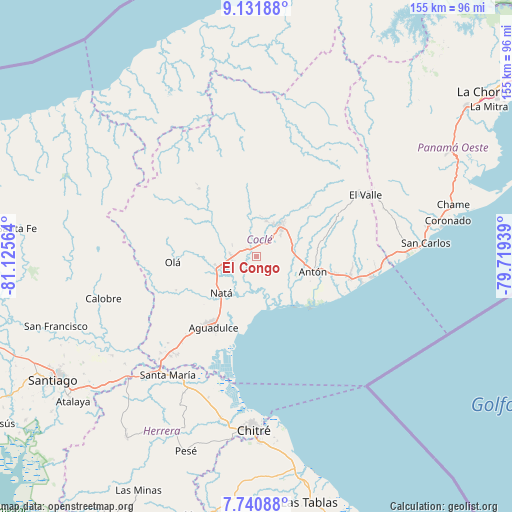
El Congo GPS coordinates[2]
8° 26' 13.236" North, 80° 25' 21.036" West
| Map corner | latitude | longitude |
|---|---|---|
| Upper-left | 9.13188°, | -81.12564° |
| Center: | 8.43701°, | -80.42251° |
| Lower-right: | 7.74088°, | -79.71939° |
| Map W x H: | 154.7×154.7 km | = 96.1×96.1mi |
| max Lat: | 9.60898° ⇑54.3% North |
| El Congo: | 8.43701° |
| min Lat: | ⇓45.7% South 7.26534° |
| min Long | El Congo | max Long |
| -82.91275° | -80.42251° | -77.38965° |
| W 56.4%⇐ | ⇒43.6% E |
Elevation
Elevation of El Congo is 28 m = 92 ft, and this is 144.1 m = 473 ft below average elevation for this country.
| Max E: |
2103 m = 6900 ft | 77% |
| Avg. | 172.1 m = 565 ft | |
| El Congo | 28 m = 92 ft | |
Min E: |
-1 m = -3 ft | 23% |
See also: Panama elevation on elevation.city.
Geographical zone
El Congo is located in North Torrid zone (between Equator and Tropic of Cancer). Distance of Equator is 938.1 km =582.9 mi to South.| Distance of | km | miles | from El Congo |
|---|---|---|---|
| North Pole | 9069 | 5635.2 | to North |
| Arctic Circle | 6463.1 | 4016 | to North |
| Tropic Cancer | 1667.8 | 1036.3 | to North |
| Equator | 938.1 | 582.9 | to South |


Nearby cities:
15 places around El Congo: (largest is in red/bold)
• Bella Vista
11.9 km =7.4 mi,  8°
8°
• Cañaveral
8.9 km =5.5 mi,  355°
355°
• Chigoré
13 km =8.1 mi,  37°
37°
• Ciruelito
3.5 km =2.2 mi,  300°
300°
• Coclé
2.2 km =1.4 mi,  341°
341°
• El Caño
11.2 km =7 mi,  249°
249°
• El Coco
9.1 km =5.7 mi,  119°
119°
• La Candelaria
7.4 km =4.6 mi,  271°
271°
• Las Guabas
6.3 km =3.9 mi,  205°
205°
• Las Lomas
9.6 km =6 mi,  34°
34°
• Llano Marín
11.6 km =7.2 mi,  67°
67°
• Los Uveros
10.6 km =6.6 mi,  16°
16°
• Penonomé
11.6 km =7.2 mi, 38°
• Río Grande
6.9 km =4.3 mi,  260°
260°
• Vista Hermosa
11.3 km =7 mi, 27°
Sources, notices
• [Note1] Compared only with cities in Panama existing in our database
• [Src1] Map data: © OpenStreetMap contributors (CC-BY-SA)
• [Src2] Other city data from geonames.org with taken over terms of usage.
• [Src3] Geographical zone / Annual Mean Temperature by Robert A. Rohde @ Wikipedia
