Ciruelito geodata
Ciruelito (Coclé) is a populated place; located in Panama in America/Panama (GMT-5) time zone. With population of 526 people, there are 466 cities with bigger population in this country. Compared to other cities in Panama, 52.9% of cities are located further ↑North; 54.9% of cities are located further ←West and 75.7% of cities have higher elevation than Ciruelito. Note1


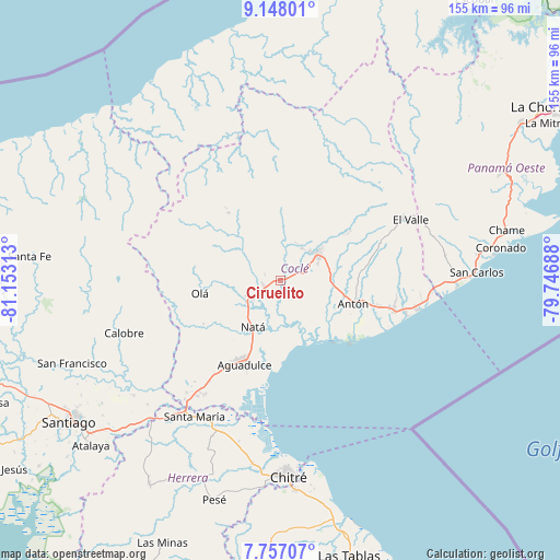
Ciruelito GPS coordinates[2]
8° 27' 11.412" North, 80° 27' 0" West
| Map corner | latitude | longitude |
|---|---|---|
| Upper-left | 9.14801°, | -81.15313° |
| Center: | 8.45317°, | -80.45° |
| Lower-right: | 7.75707°, | -79.74688° |
| Map W x H: | 154.7×154.7 km | = 96.1×96.1mi |
| max Lat: | 9.60898° ⇑52.9% North |
| Ciruelito: | 8.45317° |
| min Lat: | ⇓47.1% South 7.26534° |
| min Long | Ciruelito | max Long |
| -82.91275° | -80.45° | -77.38965° |
| W 54.9%⇐ | ⇒45.1% E |
Elevation
Elevation of Ciruelito is 29 m = 95 ft, and this is 143.1 m = 469 ft below average elevation for this country.
| Max E: |
2103 m = 6900 ft | 75.7% |
| Avg. | 172.1 m = 565 ft | |
| Ciruelito | 29 m = 95 ft | |
Min E: |
-1 m = -3 ft | 24.3% |
See also: Panama elevation on elevation.city.
Geographical zone
Ciruelito is located in North Torrid zone (between Equator and Tropic of Cancer). Distance of Equator is 939.9 km =584 mi to South.| Distance of | km | miles | from Ciruelito |
|---|---|---|---|
| North Pole | 9067.2 | 5634.1 | to North |
| Arctic Circle | 6461.3 | 4014.9 | to North |
| Tropic Cancer | 1666 | 1035.2 | to North |
| Equator | 939.9 | 584 | to South |


Nearby cities:
15 places around Ciruelito: (largest is in red/bold)
• Bella Vista
11 km =6.8 mi,  25°
25°
• Cañaveral
7.5 km =4.7 mi,  17°
17°
• Churubé Abajo
11.7 km =7.3 mi,  239°
239°
• Coclé
2.3 km =1.4 mi,  82°
82°
• El Caño
9.4 km =5.8 mi,  232°
232°
• El Coco
12.6 km =7.8 mi,  119°
119°
• El Congo
3.5 km =2.2 mi, 120°
• El Potrero
10.6 km =6.6 mi,  315°
315°
• La Candelaria
4.7 km =2.9 mi,  250°
250°
• Las Guabas
7.5 km =4.7 mi,  177°
177°
• Las Lomas
10.4 km =6.5 mi,  53°
53°
• Los Uveros
10.3 km =6.4 mi,  35°
35°
• Penonomé
12.5 km =7.8 mi, 54°
• Río Grande
4.8 km =3 mi, 232°
• Vista Hermosa
11.6 km =7.2 mi, 45°
Sources, notices
• [Note1] Compared only with cities in Panama existing in our database
• [Src1] Map data: © OpenStreetMap contributors (CC-BY-SA)
• [Src2] Other city data from geonames.org with taken over terms of usage.
• [Src3] Geographical zone / Annual Mean Temperature by Robert A. Rohde @ Wikipedia
