Coclé del Norte geodata
Coclé del Norte (Colón) is a seat of a third-order administrative division; located in Panama in America/Panama (GMT-5) time zone. With population of 388 people, there are 523 cities with bigger population in this country. Compared to other cities in Panama, 85.9% of cities are located further ↓South; 50.5% of cities are located further ←West and 99.7% of cities have higher elevation than Coclé del Norte. Note1


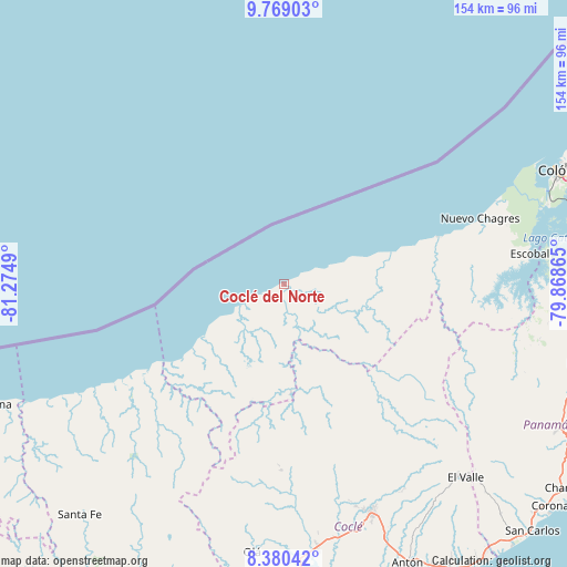
Coclé del Norte GPS coordinates[2]
9° 4' 31.44" North, 80° 34' 18.372" West
| Map corner | latitude | longitude |
|---|---|---|
| Upper-left | 9.76903°, | -81.2749° |
| Center: | 9.0754°, | -80.57177° |
| Lower-right: | 8.38042°, | -79.86865° |
| Map W x H: | 154.4×154.4 km | = 95.9×95.9mi |
| max Lat: | 9.60898° ⇑14.1% North |
| Coclé del Norte: | 9.0754° |
| min Lat: | ⇓85.9% South 7.26534° |
| min Long | Coclé del Nort | max Long |
| -82.91275° | -80.57177° | -77.38965° |
| W 50.5%⇐ | ⇒49.5% E |
Elevation
Elevation of Coclé del Norte is 1 m = 3 ft, and this is 171.1 m = 561 ft below average elevation for this country.
| Max E: |
2103 m = 6900 ft | 99.7% |
| Avg. | 172.1 m = 565 ft | |
| Coclé del Norte | 1 m = 3 ft | |
Min E: |
-1 m = -3 ft | 0.3% |
See also: Panama elevation on elevation.city.
Geographical zone
Coclé del Norte is located in North Torrid zone (between Equator and Tropic of Cancer). Distance of Equator is 1009.1 km =627 mi to South.| Distance of | km | miles | from Coclé del Norte |
|---|---|---|---|
| North Pole | 8998 | 5591.1 | to North |
| Arctic Circle | 6392.1 | 3971.9 | to North |
| Tropic Cancer | 1596.8 | 992.2 | to North |
| Equator | 1009.1 | 627 | to South |


Nearby cities:
15 places around Coclé del Norte: (largest is in red/bold)
• Boca de Río Indio
43.5 km =27 mi,  74°
74°
• Boca del Guásimo
26.8 km =16.7 mi,  95°
95°
• Cirí de Los Sotos
53.9 km =33.5 mi, 102°
• Coclecito
29.8 km =18.5 mi,  176°
176°
• El Copé
50.6 km =31.4 mi, 181°
• El Guabo
53.6 km =33.3 mi,  89°
89°
• Gobea
36.5 km =22.7 mi,  75°
75°
• La Encantada
41.8 km =26 mi, 88°
• Las Marias
44 km =27.3 mi,  118°
118°
• Las Minas
52.1 km =32.4 mi,  158°
158°
• Llano Grande
50.8 km =31.6 mi, 163°
• Machuca
50.5 km =31.4 mi, 177°
• Miguel de La Borda
30.7 km =19.1 mi, 75°
• Piedras Gordas
49.1 km =30.5 mi,  172°
172°
• Salud
50.2 km =31.2 mi, 74°
Sources, notices
• [Note1] Compared only with cities in Panama existing in our database
• [Src1] Map data: © OpenStreetMap contributors (CC-BY-SA)
• [Src2] Other city data from geonames.org with taken over terms of usage.
• [Src3] Geographical zone / Annual Mean Temperature by Robert A. Rohde @ Wikipedia
